Kunjah geodata
Kunjah (Punjab) is a populated place; located in Pakistan in Asia/Karachi (GMT+5) time zone. With population of 28,103 people, there are 220 cities with bigger population in this country. Compared to other cities in Pakistan, 75.6% of cities are located further ↓South; 89.6% of cities are located further ←West and 67.9% of cities have lower elevation than Kunjah. Note1


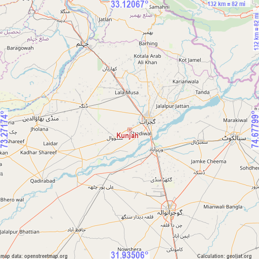
Kunjah GPS coordinates[2]
32° 31' 47.352" North, 73° 58' 29.496" East
| Map corner | latitude | longitude |
|---|---|---|
| Upper-left | 33.12067°, | 73.27174° |
| Center: | 32.52982°, | 73.97486° |
| Lower-right: | 31.93506°, | 74.67799° |
| Map W x H: | 131.8×131.8 km | = 81.9×81.9mi |
| max Lat: | 36.32162° ⇑24.4% North |
| Kunjah: | 32.52982° |
| min Lat: | ⇓75.6% South 24.14422° |
| min Long | Kunjah | max Long |
| 61.74573° | 73.97486° | 75.63372° |
| W 89.6%⇐ | ⇒10.4% E |
Elevation
Elevation of Kunjah is 234 m = 768 ft, and this is 111 m = 364 ft below average elevation for this country.
| Max E: |
2732 m = 8963 ft | 32.1% |
| Avg. | 345 m = 1132 ft | |
| Kunjah | 234 m = 768 ft | |
Min E: |
3 m = 10 ft | 67.9% |
See also: Pakistan elevation on elevation.city.
Geographical zone
Kunjah is located in North temperate zone (between Tropic of Cancer and the Arctic Circle). Distance of this Northern Tropic circle is 1011.1 km =628.3 mi to South.| Distance of | km | miles | from Kunjah |
|---|---|---|---|
| North Pole | 6390.1 | 3970.6 | to North |
| Arctic Circle | 3784.2 | 2351.4 | to North |
| Tropic Cancer | 1011.1 | 628.3 | to South |
| Equator | 3617 | 2247.5 | to South |


Nearby cities:
15 places around Kunjah: (largest is in red/bold)
• Begowala
29.3 km =18.2 mi,  110°
110°
• Bhopalwala
38.1 km =23.7 mi, 106°
• Daska Kalan
42 km =26.1 mi,  122°
122°
• Dhaunkal
20.5 km =12.7 mi,  132°
132°
• Dinga
26.9 km =16.7 mi,  297°
297°
• Gujrat
10.6 km =6.6 mi,  62°
62°
• Jalalpur Jattan
24.9 km =15.5 mi, 60°
• Kharian
32.9 km =20.4 mi,  345°
345°
• Lala Musa
19.1 km =11.9 mi,  355°
355°
• Mehmand Chak
31.8 km =19.8 mi,  333°
333°
• Phalia
38.7 km =24 mi,  253°
253°
• Rasulnagar
28.9 km =18 mi,  219°
219°
• Sambrial
36 km =22.4 mi,  99°
99°
• Sodhri
20.8 km =12.9 mi, 111°
• Wazirabad
16.7 km =10.4 mi, 125°
Sources, notices
• [Note1] Compared only with cities in Pakistan existing in our database
• [Src1] Map data: © OpenStreetMap contributors (CC-BY-SA)
• [Src2] Other city data from geonames.org with taken over terms of usage.
• [Src3] Geographical zone / Annual Mean Temperature by Robert A. Rohde @ Wikipedia
