Kandiaro geodata
Kandiaro (Sindh) is a populated place; located in Pakistan in Asia/Karachi (GMT+5) time zone. With population of 26,807 people, there are 227 cities with bigger population in this country. Compared to other cities in Pakistan, 81.3% of cities are located further ↑North; 84.9% of cities are located further →East and 81.9% of cities have higher elevation than Kandiaro. Note1


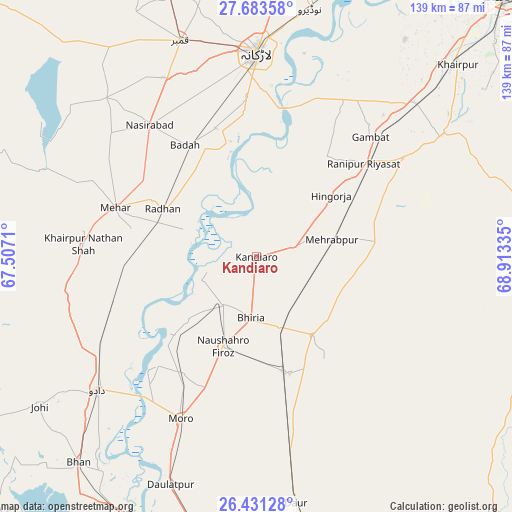
Kandiaro GPS coordinates[2]
27° 3' 33.048" North, 68° 12' 36.792" East
| Map corner | latitude | longitude |
|---|---|---|
| Upper-left | 27.68358°, | 67.5071° |
| Center: | 27.05918°, | 68.21022° |
| Lower-right: | 26.43128°, | 68.91335° |
| Map W x H: | 139.2×139.2 km | = 86.5×86.5mi |
| max Lat: | 36.32162° ⇑81.3% North |
| Kandiaro: | 27.05918° |
| min Lat: | ⇓18.7% South 24.14422° |
| min Long | Kandiaro | max Long |
| 61.74573° | 68.21022° | 75.63372° |
| W 15.1%⇐ | ⇒84.9% E |
Elevation
Elevation of Kandiaro is 51 m = 167 ft, and this is 294 m = 965 ft below average elevation for this country.
| Max E: |
2732 m = 8963 ft | 81.9% |
| Avg. | 345 m = 1132 ft | |
| Kandiaro | 51 m = 167 ft | |
Min E: |
3 m = 10 ft | 18.1% |
See also: Pakistan elevation on elevation.city.
Geographical zone
Kandiaro is located in North temperate zone (between Tropic of Cancer and the Arctic Circle). Distance of this Northern Tropic circle is 402.8 km =250.3 mi to South.| Distance of | km | miles | from Kandiaro |
|---|---|---|---|
| North Pole | 6998.4 | 4348.6 | to North |
| Arctic Circle | 4392.5 | 2729.4 | to North |
| Tropic Cancer | 402.8 | 250.3 | to South |
| Equator | 3008.7 | 1869.5 | to South |


Nearby cities:
15 places around Kandiaro: (largest is in red/bold)
• Bhiria
16.6 km =10.3 mi,  185°
185°
• Dokri
36.8 km =22.9 mi,  342°
342°
• Goth Radhan
29.8 km =18.5 mi,  301°
301°
• Hingorja
26.4 km =16.4 mi,  50°
50°
• Kandiari
34.8 km =21.6 mi,  117°
117°
• Karaundi
26.5 km =16.5 mi,  132°
132°
• Mehar
40.9 km =25.4 mi,  289°
289°
• Naushahro Firoz
25.9 km =16.1 mi,  199°
199°
• New Bādāh
36 km =22.4 mi,  330°
330°
• Pad Idan
32.9 km =20.4 mi,  164°
164°
• Ranipur
38.7 km =24 mi, 49°
• Setharja Old
30.8 km =19.1 mi,  56°
56°
• Sobhodero
33 km =20.5 mi,  34°
34°
• Sīta Road
35.8 km =22.2 mi,  265°
265°
• Tharu Shah
15.9 km =9.9 mi,  215°
215°
Sources, notices
• [Note1] Compared only with cities in Pakistan existing in our database
• [Src1] Map data: © OpenStreetMap contributors (CC-BY-SA)
• [Src2] Other city data from geonames.org with taken over terms of usage.
• [Src3] Geographical zone / Annual Mean Temperature by Robert A. Rohde @ Wikipedia
