Kunri geodata
Kunri (Sindh) is a populated place; located in Pakistan in Asia/Karachi (GMT+5) time zone. With population of 26,773 people, there are 229 cities with bigger population in this country. Compared to other cities in Pakistan, 93.5% of cities are located further ↑North; 65.5% of cities are located further →East and 95.5% of cities have higher elevation than Kunri. Note1


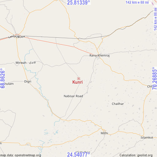
Kunri GPS coordinates[2]
25° 10' 43.464" North, 69° 33' 56.592" East
| Map corner | latitude | longitude |
|---|---|---|
| Upper-left | 25.81339°, | 68.8626° |
| Center: | 25.17874°, | 69.56572° |
| Lower-right: | 24.54077°, | 70.26885° |
| Map W x H: | 141.5×141.5 km | = 87.9×87.9mi |
| max Lat: | 36.32162° ⇑93.5% North |
| Kunri: | 25.17874° |
| min Lat: | ⇓6.5% South 24.14422° |
| min Long | Kunri | max Long |
| 61.74573° | 69.56572° | 75.63372° |
| W 34.5%⇐ | ⇒65.5% E |
Elevation
Elevation of Kunri is 14 m = 46 ft, and this is 331 m = 1086 ft below average elevation for this country.
| Max E: |
2732 m = 8963 ft | 95.5% |
| Avg. | 345 m = 1132 ft | |
| Kunri | 14 m = 46 ft | |
Min E: |
3 m = 10 ft | 4.5% |
See also: Pakistan elevation on elevation.city.
Geographical zone
Kunri is located in North temperate zone (between Tropic of Cancer and the Arctic Circle). Distance of this Northern Tropic circle is 193.7 km =120.4 mi to South.| Distance of | km | miles | from Kunri |
|---|---|---|---|
| North Pole | 7207.4 | 4478.5 | to North |
| Arctic Circle | 4601.6 | 2859.3 | to North |
| Tropic Cancer | 193.7 | 120.4 | to South |
| Equator | 2799.6 | 1739.6 | to South |


Nearby cities:
15 places around Kunri: (largest is in red/bold)
• Chamber
76.9 km =47.8 mi,  279°
279°
• Chhor
43.1 km =26.8 mi,  30°
30°
• Dhoro Naro
36.3 km =22.6 mi,  0°
0°
• Digri
45.8 km =28.5 mi,  266°
266°
• Diplo
79.2 km =49.2 mi,  178°
178°
• Mirpur Khas
67.8 km =42.1 mi,  304°
304°
• Mirwah Gorchani
53.9 km =33.5 mi,  285°
285°
• Mithi
54.4 km =33.8 mi,  154°
154°
• Nabisar
14.7 km =9.1 mi, 147°
• Naukot
39.3 km =24.4 mi,  204°
204°
• Pithoro
41.5 km =25.8 mi,  332°
332°
• Rajo Khanani
74.9 km =46.5 mi,  253°
253°
• Samaro
20.5 km =12.7 mi, 303°
• Tando Bago
74.4 km =46.2 mi,  234°
234°
• Umarkot
27.1 km =16.8 mi,  40°
40°
Sources, notices
• [Note1] Compared only with cities in Pakistan existing in our database
• [Src1] Map data: © OpenStreetMap contributors (CC-BY-SA)
• [Src2] Other city data from geonames.org with taken over terms of usage.
• [Src3] Geographical zone / Annual Mean Temperature by Robert A. Rohde @ Wikipedia
