Pithoro geodata
Pithoro (Sindh) is a populated place; located in Pakistan in Asia/Karachi (GMT+5) time zone. With population of 6,440 people, there are 381 cities with bigger population in this country. Compared to other cities in Pakistan, 90.5% of cities are located further ↑North; 67% of cities are located further →East and 96.6% of cities have higher elevation than Pithoro. Note1


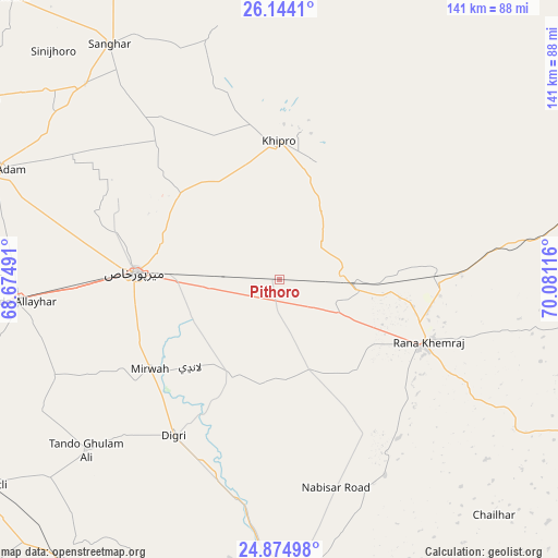
Pithoro GPS coordinates[2]
25° 30' 40.392" North, 69° 22' 40.908" East
| Map corner | latitude | longitude |
|---|---|---|
| Upper-left | 26.1441°, | 68.67491° |
| Center: | 25.51122°, | 69.37803° |
| Lower-right: | 24.87498°, | 70.08116° |
| Map W x H: | 141.1×141.1 km | = 87.7×87.7mi |
| max Lat: | 36.32162° ⇑90.5% North |
| Pithoro: | 25.51122° |
| min Lat: | ⇓9.5% South 24.14422° |
| min Long | Pithoro | max Long |
| 61.74573° | 69.37803° | 75.63372° |
| W 33%⇐ | ⇒67% E |
Elevation
Elevation of Pithoro is 12 m = 39 ft, and this is 333 m = 1093 ft below average elevation for this country.
| Max E: |
2732 m = 8963 ft | 96.6% |
| Avg. | 345 m = 1132 ft | |
| Pithoro | 12 m = 39 ft | |
Min E: |
3 m = 10 ft | 3.4% |
See also: Pakistan elevation on elevation.city.
Geographical zone
Pithoro is located in North temperate zone (between Tropic of Cancer and the Arctic Circle). Distance of this Northern Tropic circle is 230.7 km =143.4 mi to South.| Distance of | km | miles | from Pithoro |
|---|---|---|---|
| North Pole | 7170.5 | 4455.5 | to North |
| Arctic Circle | 4564.6 | 2836.3 | to North |
| Tropic Cancer | 230.7 | 143.4 | to South |
| Equator | 2836.6 | 1762.6 | to South |


Nearby cities:
15 places around Pithoro: (largest is in red/bold)
• Berani
64.8 km =40.3 mi,  298°
298°
• Chamber
61.8 km =38.4 mi,  246°
246°
• Chhor
40.8 km =25.4 mi,  89°
89°
• Dhoro Naro
19.4 km =12.1 mi, 92°
• Digri
47.7 km =29.6 mi,  214°
214°
• Jhol
69.6 km =43.2 mi,  315°
315°
• Kunri
41.5 km =25.8 mi,  152°
152°
• Mirpur Khas
36.7 km =22.8 mi,  272°
272°
• Mirwah Gorchani
39.8 km =24.7 mi,  235°
235°
• Nabisar
56.1 km =34.9 mi, 151°
• Naukot
72.6 km =45.1 mi,  178°
178°
• Samaro
25.6 km =15.9 mi, 175°
• Tando Allahyar
66.5 km =41.3 mi, 265°
• Tando Mitha Khan
56.7 km =35.2 mi,  341°
341°
• Umarkot
40.1 km =24.9 mi,  114°
114°
Sources, notices
• [Note1] Compared only with cities in Pakistan existing in our database
• [Src1] Map data: © OpenStreetMap contributors (CC-BY-SA)
• [Src2] Other city data from geonames.org with taken over terms of usage.
• [Src3] Geographical zone / Annual Mean Temperature by Robert A. Rohde @ Wikipedia
