Swabi geodata
Swabi (Khyber Pakhtunkhwa) is a seat of a second-order administrative division; located in Pakistan in Asia/Karachi (GMT+5) time zone. With population of 97,363 people, there are 67 cities with bigger population in this country. Compared to other cities in Pakistan, 92.1% of cities are located further ↓South; 64.3% of cities are located further ←West and 78.1% of cities have lower elevation than Swabi. Note1


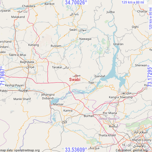
Swabi GPS coordinates[2]
34° 7' 12.648" North, 72° 28' 11.352" East
| Map corner | latitude | longitude |
|---|---|---|
| Upper-left | 34.70026°, | 71.7667° |
| Center: | 34.12018°, | 72.46982° |
| Lower-right: | 33.53609°, | 73.17295° |
| Map W x H: | 129.4×129.4 km | = 80.4×80.4mi |
| max Lat: | 36.32162° ⇑7.9% North |
| Swabi: | 34.12018° |
| min Lat: | ⇓92.1% South 24.14422° |
| min Long | Swabi | max Long |
| 61.74573° | 72.46982° | 75.63372° |
| W 64.3%⇐ | ⇒35.7% E |
Elevation
Elevation of Swabi is 341 m = 1119 ft, and this is 4 m = 13 ft below average elevation for this country.
| Max E: |
2732 m = 8963 ft | 21.9% |
| Avg. | 345 m = 1132 ft | |
| Swabi | 341 m = 1119 ft | |
Min E: |
3 m = 10 ft | 78.1% |
See also: Swabi elevation on elevation.city.
Geographical zone
Swabi is located in North temperate zone (between Tropic of Cancer and the Arctic Circle). Distance of this Northern Tropic circle is 1187.9 km =738.1 mi to South.| Distance of | km | miles | from Swabi |
|---|---|---|---|
| North Pole | 6213.3 | 3860.8 | to North |
| Arctic Circle | 3607.4 | 2241.5 | to North |
| Tropic Cancer | 1187.9 | 738.1 | to South |
| Equator | 3793.8 | 2357.4 | to South |


Nearby cities:
15 places around Swabi: (largest is in red/bold)
• Akora
34.3 km =21.3 mi,  247°
247°
• Ashanagro Koto
20.7 km =12.9 mi,  266°
266°
• Attock City
40.6 km =25.2 mi,  194°
194°
• Daggar
43.5 km =27 mi,  1°
1°
• Haripur
45 km =28 mi,  107°
107°
• Hazro City
23.5 km =14.6 mi,  175°
175°
• Khalabat
39.2 km =24.4 mi,  99°
99°
• Mardan
39.6 km =24.6 mi,  282°
282°
• Noorabad
48.6 km =30.2 mi,  287°
287°
• Nowshera
46.5 km =28.9 mi,  255°
255°
• Nowshera Cantonment
45.5 km =28.3 mi, 252°
• Risalpur Cantonment
44.4 km =27.6 mi, 261°
• Sanjwal
40.1 km =24.9 mi, 184°
• Topi
15 km =9.3 mi, 111°
• Zaida
6.8 km =4.2 mi, 182°
Sources, notices
• [Note1] Compared only with cities in Pakistan existing in our database
• [Src1] Map data: © OpenStreetMap contributors (CC-BY-SA)
• [Src2] Other city data from geonames.org with taken over terms of usage.
• [Src3] Geographical zone / Annual Mean Temperature by Robert A. Rohde @ Wikipedia
