Zaida geodata
Zaida (Khyber Pakhtunkhwa) is a populated place; located in Pakistan in Asia/Karachi (GMT+5) time zone. With population of 26,787 people, there are 228 cities with bigger population in this country. Compared to other cities in Pakistan, 90.7% of cities are located further ↓South; 63.9% of cities are located further ←West and 76.5% of cities have lower elevation than Zaida. Note1


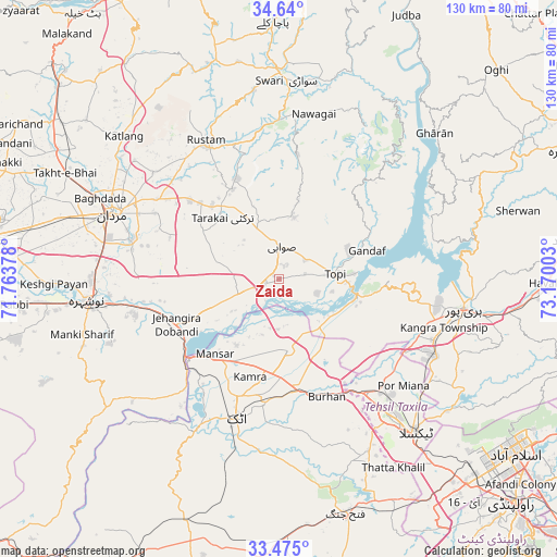
Zaida GPS coordinates[2]
34° 3' 34.2" North, 72° 28' 0.84" East
| Map corner | latitude | longitude |
|---|---|---|
| Upper-left | 34.64°, | 71.76378° |
| Center: | 34.0595°, | 72.4669° |
| Lower-right: | 33.475°, | 73.17003° |
| Map W x H: | 129.5×129.5 km | = 80.5×80.5mi |
| max Lat: | 36.32162° ⇑9.3% North |
| Zaida: | 34.0595° |
| min Lat: | ⇓90.7% South 24.14422° |
| min Long | Zaida | max Long |
| 61.74573° | 72.4669° | 75.63372° |
| W 63.9%⇐ | ⇒36.1% E |
Elevation
Elevation of Zaida is 320 m = 1050 ft, and this is 25 m = 82 ft below average elevation for this country.
| Max E: |
2732 m = 8963 ft | 23.5% |
| Avg. | 345 m = 1132 ft | |
| Zaida | 320 m = 1050 ft | |
Min E: |
3 m = 10 ft | 76.5% |
See also: Pakistan elevation on elevation.city.
Geographical zone
Zaida is located in North temperate zone (between Tropic of Cancer and the Arctic Circle). Distance of this Northern Tropic circle is 1181.1 km =733.9 mi to South.| Distance of | km | miles | from Zaida |
|---|---|---|---|
| North Pole | 6220 | 3864.9 | to North |
| Arctic Circle | 3614.1 | 2245.7 | to North |
| Tropic Cancer | 1181.1 | 733.9 | to South |
| Equator | 3787.1 | 2353.2 | to South |


Nearby cities:
15 places around Zaida: (largest is in red/bold)
• Akora
32.1 km =19.9 mi,  258°
258°
• Aman Garh
49.9 km =31 mi, 263°
• Ashanagro Koto
21.1 km =13.1 mi,  284°
284°
• Attock City
34 km =21.1 mi,  196°
196°
• Daggar
50.2 km =31.2 mi,  1°
1°
• Haripur
43.7 km =27.2 mi,  99°
99°
• Hazro City
16.8 km =10.4 mi,  172°
172°
• Khalabat
38.9 km =24.2 mi,  89°
89°
• Mardan
41.4 km =25.7 mi,  291°
291°
• Nowshera
45 km =28 mi, 263°
• Nowshera Cantonment
43.7 km =27.2 mi, 261°
• Risalpur Cantonment
43.7 km =27.2 mi,  270°
270°
• Sanjwal
33.3 km =20.7 mi,  185°
185°
• Swabi
6.8 km =4.2 mi, 2°
• Topi
14.3 km =8.9 mi, 85°
Sources, notices
• [Note1] Compared only with cities in Pakistan existing in our database
• [Src1] Map data: © OpenStreetMap contributors (CC-BY-SA)
• [Src2] Other city data from geonames.org with taken over terms of usage.
• [Src3] Geographical zone / Annual Mean Temperature by Robert A. Rohde @ Wikipedia
