Darya Khan geodata
Darya Khan (Punjab) is a populated place; located in Pakistan in Asia/Karachi (GMT+5) time zone. With population of 15,048 people, there are 313 cities with bigger population in this country. Compared to other cities in Pakistan, 61.9% of cities are located further ↓South; 53.5% of cities are located further →East and 51% of cities have higher elevation than Darya Khan. Note1


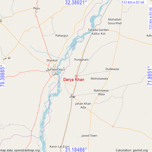
Darya Khan GPS coordinates[2]
31° 47' 4.092" North, 71° 6' 7.092" East
| Map corner | latitude | longitude |
|---|---|---|
| Upper-left | 32.38021°, | 70.39885° |
| Center: | 31.78447°, | 71.10197° |
| Lower-right: | 31.18486°, | 71.8051° |
| Map W x H: | 132.9×132.9 km | = 82.6×82.6mi |
| max Lat: | 36.32162° ⇑38.1% North |
| Darya Khan: | 31.78447° |
| min Lat: | ⇓61.9% South 24.14422° |
| min Long | Darya Khan | max Long |
| 61.74573° | 71.10197° | 75.63372° |
| W 46.5%⇐ | ⇒53.5% E |
Elevation
Elevation of Darya Khan is 176 m = 577 ft, and this is 169 m = 554 ft below average elevation for this country.
| Max E: |
2732 m = 8963 ft | 51% |
| Avg. | 345 m = 1132 ft | |
| Darya Khan | 176 m = 577 ft | |
Min E: |
3 m = 10 ft | 49% |
See also: Pakistan elevation on elevation.city.
Geographical zone
Darya Khan is located in North temperate zone (between Tropic of Cancer and the Arctic Circle). Distance of this Northern Tropic circle is 928.2 km =576.8 mi to South.| Distance of | km | miles | from Darya Khan |
|---|---|---|---|
| North Pole | 6473 | 4022.1 | to North |
| Arctic Circle | 3867.1 | 2402.9 | to North |
| Tropic Cancer | 928.2 | 576.8 | to South |
| Equator | 3534.1 | 2196 | to South |


Nearby cities:
15 places around Darya Khan: (largest is in red/bold)
• Bhakkar
17.9 km =11.1 mi,  191°
191°
• Chak Two Hundred Forty-nine Thal Development Authority
68.2 km =42.4 mi,  171°
171°
• Dera Ismail Khan
19.6 km =12.2 mi,  285°
285°
• Dullewala
32.1 km =19.9 mi,  80°
80°
• Harnoli
69.6 km =43.2 mi,  37°
37°
• Kalur Kot
44 km =27.3 mi,  20°
20°
• Karor
63.9 km =39.7 mi, 192°
• Kulachi
62.8 km =39 mi,  284°
284°
• Kundian
82.9 km =51.5 mi,  25°
25°
• Lakki
93.2 km =57.9 mi,  348°
348°
• Layyah
92.8 km =57.7 mi, 189°
• Mankera
54.5 km =33.9 mi,  143°
143°
• Paharpur
37.7 km =23.4 mi,  340°
340°
• Shorkot
25.4 km =15.8 mi,  303°
303°
• Tank
83.1 km =51.6 mi,  305°
305°
Sources, notices
• [Note1] Compared only with cities in Pakistan existing in our database
• [Src1] Map data: © OpenStreetMap contributors (CC-BY-SA)
• [Src2] Other city data from geonames.org with taken over terms of usage.
• [Src3] Geographical zone / Annual Mean Temperature by Robert A. Rohde @ Wikipedia
