Bhakkar geodata
Bhakkar (Punjab) is a seat of a second-order administrative division; located in Pakistan in Asia/Karachi (GMT+5) time zone. With population of 81,950 people, there are 80 cities with bigger population in this country. Compared to other cities in Pakistan, 60.5% of cities are located further ↓South; 54% of cities are located further →East and 53% of cities have higher elevation than Bhakkar. Note1


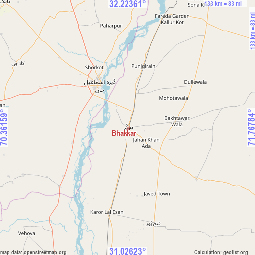
Bhakkar GPS coordinates[2]
31° 37' 36.66" North, 71° 3' 52.956" East
| Map corner | latitude | longitude |
|---|---|---|
| Upper-left | 32.22361°, | 70.36159° |
| Center: | 31.62685°, | 71.06471° |
| Lower-right: | 31.02623°, | 71.76784° |
| Map W x H: | 133.1×133.1 km | = 82.7×82.7mi |
| max Lat: | 36.32162° ⇑39.5% North |
| Bhakkar: | 31.62685° |
| min Lat: | ⇓60.5% South 24.14422° |
| min Long | Bhakkar | max Long |
| 61.74573° | 71.06471° | 75.63372° |
| W 46%⇐ | ⇒54% E |
Elevation
Elevation of Bhakkar is 171 m = 561 ft, and this is 174 m = 571 ft below average elevation for this country.
| Max E: |
2732 m = 8963 ft | 53% |
| Avg. | 345 m = 1132 ft | |
| Bhakkar | 171 m = 561 ft | |
Min E: |
3 m = 10 ft | 47% |
See also: Bhakkar elevation on elevation.city.
Geographical zone
Bhakkar is located in North temperate zone (between Tropic of Cancer and the Arctic Circle). Distance of this Northern Tropic circle is 910.7 km =565.9 mi to South.| Distance of | km | miles | from Bhakkar |
|---|---|---|---|
| North Pole | 6490.5 | 4033 | to North |
| Arctic Circle | 3884.6 | 2413.8 | to North |
| Tropic Cancer | 910.7 | 565.9 | to South |
| Equator | 3516.6 | 2185.1 | to South |


Nearby cities:
15 places around Bhakkar: (largest is in red/bold)
• Basti Dosa
95.2 km =59.2 mi,  191°
191°
• Chak Two Hundred Forty-nine Thal Development Authority
51.7 km =32.1 mi,  165°
165°
• Darya Khan
17.9 km =11.1 mi,  11°
11°
• Dera Ismail Khan
27.5 km =17.1 mi,  325°
325°
• Dullewala
42 km =26.1 mi,  56°
56°
• Harnoli
85.9 km =53.4 mi,  32°
32°
• Kalur Kot
61.7 km =38.3 mi,  17°
17°
• Karor
46 km =28.6 mi, 193°
• Kulachi
66.4 km =41.3 mi,  300°
300°
• Layyah
75 km =46.6 mi, 189°
• Mankera
44.5 km =27.7 mi,  126°
126°
• Moza Shahwala
93.6 km =58.2 mi, 192°
• Paharpur
53.9 km =33.5 mi,  350°
350°
• Shorkot
36.1 km =22.4 mi, 330°
• Tank
91.9 km =57.1 mi,  315°
315°
Sources, notices
• [Note1] Compared only with cities in Pakistan existing in our database
• [Src1] Map data: © OpenStreetMap contributors (CC-BY-SA)
• [Src2] Other city data from geonames.org with taken over terms of usage.
• [Src3] Geographical zone / Annual Mean Temperature by Robert A. Rohde @ Wikipedia
