Landi Kotal geodata
Landi Kotal (FATA) is a populated place; located in Pakistan in Asia/Karachi (GMT+5) time zone. With population of 2,223 people, there are 395 cities with bigger population in this country. Compared to other cities in Pakistan, 91.6% of cities are located further ↓South; 53.3% of cities are located further →East and 90.3% of cities have lower elevation than Landi Kotal. Note1


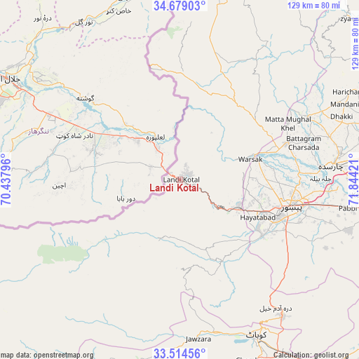
Landi Kotal GPS coordinates[2]
34° 5' 55.68" North, 71° 8' 27.888" East
| Map corner | latitude | longitude |
|---|---|---|
| Upper-left | 34.67903°, | 70.43796° |
| Center: | 34.0988°, | 71.14108° |
| Lower-right: | 33.51456°, | 71.84421° |
| Map W x H: | 129.5×129.5 km | = 80.5×80.5mi |
| max Lat: | 36.32162° ⇑8.4% North |
| Landi Kotal: | 34.0988° |
| min Lat: | ⇓91.6% South 24.14422° |
| min Long | Landi Kotal | max Long |
| 61.74573° | 71.14108° | 75.63372° |
| W 46.7%⇐ | ⇒53.3% E |
Elevation
Elevation of Landi Kotal is 1064 m = 3491 ft, and this is 719 m = 2359 ft above average elevation for this country.
| Max E: |
2732 m = 8963 ft | 9.7% |
| Landi Kotal | 1064 m 3491 ft | |
| Avg. | 345 m = 1132 ft | |
Min E: |
3 m = 10 ft | 90.3% |
See also: Pakistan elevation on elevation.city.
Geographical zone
Landi Kotal is located in North temperate zone (between Tropic of Cancer and the Arctic Circle). Distance of this Northern Tropic circle is 1185.5 km =736.6 mi to South.| Distance of | km | miles | from Landi Kotal |
|---|---|---|---|
| North Pole | 6215.6 | 3862.2 | to North |
| Arctic Circle | 3609.7 | 2243 | to North |
| Tropic Cancer | 1185.5 | 736.6 | to South |
| Equator | 3791.4 | 2355.9 | to South |


Nearby cities:
15 places around Landi Kotal: (largest is in red/bold)
• Aman Garh
73.4 km =45.6 mi,  98°
98°
• Charsadda
55.5 km =34.5 mi,  84°
84°
• Cherat Cantonement
75.8 km =47.1 mi,  113°
113°
• Hangu
63.5 km =39.5 mi,  186°
186°
• Kohat
64.1 km =39.8 mi,  153°
153°
• Noorabad
77.8 km =48.3 mi, 77°
• Nowshera
77.9 km =48.4 mi, 96°
• Nowshera Cantonment
79.8 km =49.6 mi, 98°
• Pabbi
61 km =37.9 mi, 99°
• Peshawar
41.5 km =25.8 mi, 104°
• Risalpur Cantonment
78.5 km =48.8 mi,  93°
93°
• Shabqadar
40.2 km =25 mi,  71°
71°
• Shinpokh
25.9 km =16.1 mi,  7°
7°
• Tangi
52.1 km =32.4 mi,  64°
64°
• Utmanzai
58.1 km =36.1 mi, 80°
Sources, notices
• [Note1] Compared only with cities in Pakistan existing in our database
• [Src1] Map data: © OpenStreetMap contributors (CC-BY-SA)
• [Src2] Other city data from geonames.org with taken over terms of usage.
• [Src3] Geographical zone / Annual Mean Temperature by Robert A. Rohde @ Wikipedia
