Hangu geodata
Hangu (Khyber Pakhtunkhwa) is a seat of a second-order administrative division; located in Pakistan in Asia/Karachi (GMT+5) time zone. With population of 36,150 people, there are 173 cities with bigger population in this country. Compared to other cities in Pakistan, 85.6% of cities are located further ↓South; 54.2% of cities are located further →East and 86.2% of cities have lower elevation than Hangu. Note1


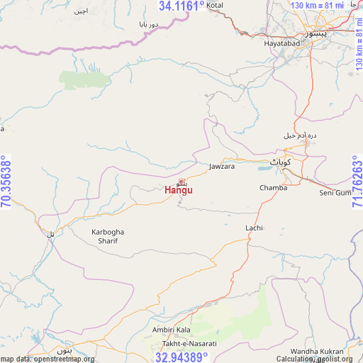
Hangu GPS coordinates[2]
33° 31' 55.128" North, 71° 3' 34.2" East
| Map corner | latitude | longitude |
|---|---|---|
| Upper-left | 34.1161°, | 70.35638° |
| Center: | 33.53198°, | 71.0595° |
| Lower-right: | 32.94389°, | 71.76263° |
| Map W x H: | 130.3×130.3 km | = 81×81mi |
| max Lat: | 36.32162° ⇑14.4% North |
| Hangu: | 33.53198° |
| min Lat: | ⇓85.6% South 24.14422° |
| min Long | Hangu | max Long |
| 61.74573° | 71.0595° | 75.63372° |
| W 45.8%⇐ | ⇒54.2% E |
Elevation
Elevation of Hangu is 840 m = 2756 ft, and this is 495 m = 1624 ft above average elevation for this country.
| Max E: |
2732 m = 8963 ft | 13.8% |
| Hangu | 840 m 2756 ft | |
| Avg. | 345 m = 1132 ft | |
Min E: |
3 m = 10 ft | 86.2% |
See also: Pakistan elevation on elevation.city.
Geographical zone
Hangu is located in North temperate zone (between Tropic of Cancer and the Arctic Circle). Distance of this Northern Tropic circle is 1122.5 km =697.5 mi to South.| Distance of | km | miles | from Hangu |
|---|---|---|---|
| North Pole | 6278.7 | 3901.4 | to North |
| Arctic Circle | 3672.8 | 2282.2 | to North |
| Tropic Cancer | 1122.5 | 697.5 | to South |
| Equator | 3728.4 | 2316.7 | to South |


Nearby cities:
15 places around Hangu: (largest is in red/bold)
• Alizai
66.1 km =41.1 mi,  270°
270°
• Bannu
74.1 km =46 mi,  214°
214°
• Cherat Cantonement
83.6 km =51.9 mi,  67°
67°
• Daud Khel
87.2 km =54.2 mi,  146°
146°
• Doaba
32.2 km =20 mi,  248°
248°
• Kalabagh
77.9 km =48.4 mi,  144°
144°
• Kamar Mushani
81.6 km =50.7 mi,  159°
159°
• Karak
46.3 km =28.8 mi,  176°
176°
• Kohat
36.5 km =22.7 mi,  81°
81°
• Lachi
30.6 km =19 mi,  122°
122°
• Landi Kotal
63.5 km =39.5 mi,  6°
6°
• Pabbi
86.2 km =53.6 mi,  51°
51°
• Peshawar
71.4 km =44.4 mi,  42°
42°
• Sarai Naurang
82.7 km =51.4 mi,  198°
198°
• Shabqadar
88.7 km =55.1 mi,  31°
31°
Sources, notices
• [Note1] Compared only with cities in Pakistan existing in our database
• [Src1] Map data: © OpenStreetMap contributors (CC-BY-SA)
• [Src2] Other city data from geonames.org with taken over terms of usage.
• [Src3] Geographical zone / Annual Mean Temperature by Robert A. Rohde @ Wikipedia
