Shinpokh geodata
Shinpokh (FATA) is a populated place; located in Pakistan in Asia/Karachi (GMT+5) time zone. With population of 1,111 people, there are 409 cities with bigger population in this country. Compared to other cities in Pakistan, 94.4% of cities are located further ↓South; 52.8% of cities are located further →East and 80.1% of cities have lower elevation than Shinpokh. Note1


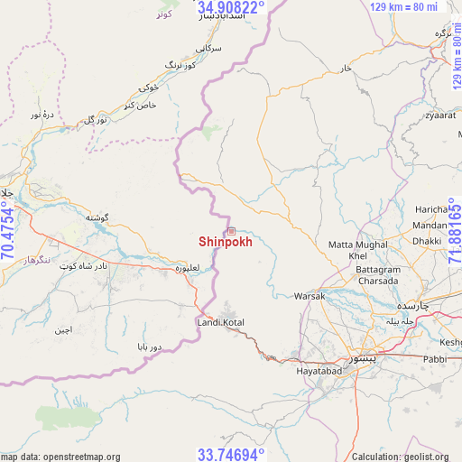
Shinpokh GPS coordinates[2]
34° 19' 46.524" North, 71° 10' 42.672" East
| Map corner | latitude | longitude |
|---|---|---|
| Upper-left | 34.90822°, | 70.4754° |
| Center: | 34.32959°, | 71.17852° |
| Lower-right: | 33.74694°, | 71.88165° |
| Map W x H: | 129.1×129.1 km | = 80.2×80.2mi |
| max Lat: | 36.32162° ⇑5.6% North |
| Shinpokh: | 34.32959° |
| min Lat: | ⇓94.4% South 24.14422° |
| min Long | Shinpokh | max Long |
| 61.74573° | 71.17852° | 75.63372° |
| W 47.2%⇐ | ⇒52.8% E |
Elevation
Elevation of Shinpokh is 402 m = 1319 ft, and this is 57 m = 187 ft above average elevation for this country.
| Max E: |
2732 m = 8963 ft | 19.9% |
| Shinpokh | 402 m 1319 ft | |
| Avg. | 345 m = 1132 ft | |
Min E: |
3 m = 10 ft | 80.1% |
See also: Pakistan elevation on elevation.city.
Geographical zone
Shinpokh is located in North temperate zone (between Tropic of Cancer and the Arctic Circle). Distance of this Northern Tropic circle is 1211.2 km =752.6 mi to South.| Distance of | km | miles | from Shinpokh |
|---|---|---|---|
| North Pole | 6190 | 3846.3 | to North |
| Arctic Circle | 3584.1 | 2227.1 | to North |
| Tropic Cancer | 1211.2 | 752.6 | to South |
| Equator | 3817.1 | 2371.8 | to South |


Nearby cities:
15 places around Shinpokh: (largest is in red/bold)
• Aman Garh
77.9 km =48.4 mi,  117°
117°
• Bat Khela
79.5 km =49.4 mi,  66°
66°
• Charsadda
55.5 km =34.5 mi,  111°
111°
• Landi Kotal
25.9 km =16.1 mi,  187°
187°
• Malakand
73.8 km =45.9 mi, 69°
• Mardan
81.4 km =50.6 mi,  100°
100°
• Noorabad
72.9 km =45.3 mi, 96°
• Nowshera
81.7 km =50.8 mi, 115°
• Pabbi
66.9 km =41.6 mi, 122°
• Peshawar
51.3 km =31.9 mi,  134°
134°
• Risalpur Cantonment
80.6 km =50.1 mi, 111°
• Shabqadar
36.8 km =22.9 mi, 110°
• Tangi
43.6 km =27.1 mi,  94°
94°
• Timargara
82.3 km =51.1 mi,  47°
47°
• Utmanzai
56 km =34.8 mi, 106°
Sources, notices
• [Note1] Compared only with cities in Pakistan existing in our database
• [Src1] Map data: © OpenStreetMap contributors (CC-BY-SA)
• [Src2] Other city data from geonames.org with taken over terms of usage.
• [Src3] Geographical zone / Annual Mean Temperature by Robert A. Rohde @ Wikipedia
