Narowal geodata
Narowal (Punjab) is a seat of a second-order administrative division; located in Pakistan in Asia/Karachi (GMT+5) time zone. With population of 68,291 people, there are 102 cities with bigger population in this country. Compared to other cities in Pakistan, 67.3% of cities are located further ↓South; 99.1% of cities are located further ←West and 70% of cities have lower elevation than Narowal. Note1


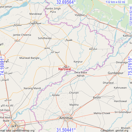
Narowal GPS coordinates[2]
32° 6' 7.092" North, 74° 52' 22.908" East
| Map corner | latitude | longitude |
|---|---|---|
| Upper-left | 32.69564°, | 74.16991° |
| Center: | 32.10197°, | 74.87303° |
| Lower-right: | 31.50441°, | 75.57616° |
| Map W x H: | 132.5×132.5 km | = 82.3×82.3mi |
| max Lat: | 36.32162° ⇑32.7% North |
| Narowal: | 32.10197° |
| min Lat: | ⇓67.3% South 24.14422° |
| min Long | Narowal | max Long |
| 61.74573° | 74.87303° | 75.63372° |
| W 99.1%⇐ | ⇒0.90000000000001% E |
Elevation
Elevation of Narowal is 241 m = 791 ft, and this is 104 m = 341 ft below average elevation for this country.
| Max E: |
2732 m = 8963 ft | 30% |
| Avg. | 345 m = 1132 ft | |
| Narowal | 241 m = 791 ft | |
Min E: |
3 m = 10 ft | 70% |
See also: Narowal elevation on elevation.city.
Geographical zone
Narowal is located in North temperate zone (between Tropic of Cancer and the Arctic Circle). Distance of this Northern Tropic circle is 963.5 km =598.7 mi to South.| Distance of | km | miles | from Narowal |
|---|---|---|---|
| North Pole | 6437.7 | 4000.2 | to North |
| Arctic Circle | 3831.8 | 2381 | to North |
| Tropic Cancer | 963.5 | 598.7 | to South |
| Equator | 3569.4 | 2217.9 | to South |


Nearby cities:
15 places around Narowal: (largest is in red/bold)
• Baddomalhi
23.3 km =14.5 mi,  237°
237°
• Bhopalwala
60.2 km =37.4 mi,  307°
307°
• Chawinda
31.2 km =19.4 mi,  329°
329°
• Daska Kalan
55 km =34.2 mi,  296°
296°
• Eminabad
58.1 km =36.1 mi,  263°
263°
• Fazilpur
19.9 km =12.4 mi,  65°
65°
• Kalaswala
23.8 km =14.8 mi, 297°
• Kamoke
62.9 km =39.1 mi, 257°
• Kot Ghulam Muhammad
40 km =24.9 mi, 309°
• Kot Rajkour
41.4 km =25.7 mi, 326°
• Narang Mandi
40.2 km =25 mi, 236°
• Pasrur
26.6 km =16.5 mi, 312°
• Shakargarh
32.4 km =20.1 mi,  56°
56°
• Sialkot
54 km =33.6 mi,  323°
323°
• Zafarwal
27.1 km =16.8 mi,  5°
5°
Sources, notices
• [Note1] Compared only with cities in Pakistan existing in our database
• [Src1] Map data: © OpenStreetMap contributors (CC-BY-SA)
• [Src2] Other city data from geonames.org with taken over terms of usage.
• [Src3] Geographical zone / Annual Mean Temperature by Robert A. Rohde @ Wikipedia
