Żuromin geodata
Żuromin (Mazovia) is a seat of a second-order administrative division; located in Poland in Europe/Warsaw (GMT+2) time zone. With population of 9,019 people, there are 478 cities with bigger population in this country. Compared to other cities in Poland, 84.4% of cities are located further ↓South; 56.9% of cities are located further ←West and 63.7% of cities have higher elevation than Żuromin. Note1


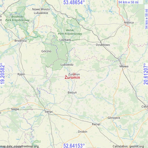
Żuromin GPS coordinates[2]
53° 3' 57.996" North, 19° 54' 32.184" East
| Map corner | latitude | longitude |
|---|---|---|
| Upper-left | 53.48654°, | 19.20582° |
| Center: | 53.06611°, | 19.90894° |
| Lower-right: | 52.64153°, | 20.61207° |
| Map W x H: | 94×94 km | = 58.4×58.4mi |
| max Lat: | 54.83135° ⇑15.6% North |
| Żuromin: | 53.06611° |
| min Lat: | ⇓84.4% South 49.21328° |
| min Long | Żuromin | max Long |
| 14.20249° | 19.90894° | 24.03723° |
| W 56.9%⇐ | ⇒43.1% E |
Elevation
Elevation of Żuromin is 137 m = 449 ft, and this is 54.4 m = 178 ft below average elevation for this country.
| Max E: |
974 m = 3196 ft | 63.7% |
| Avg. | 191.4 m = 628 ft | |
| Żuromin | 137 m = 449 ft | |
Min E: |
-3 m = -10 ft | 36.3% |
See also: Poland elevation on elevation.city.
Geographical zone
Żuromin is located in North temperate zone (between Tropic of Cancer and the Arctic Circle). Distance of this North polar circle is 1500.8 km =932.6 mi to North.| Distance of | km | miles | from Żuromin |
|---|---|---|---|
| North Pole | 4106.7 | 2551.8 | to North |
| Arctic Circle | 1500.8 | 932.6 | to North |
| Tropic Cancer | 3294.5 | 2047.1 | to South |
| Equator | 5900.4 | 3666.3 | to South |


Nearby cities:
15 places around Żuromin: (largest is in red/bold)
• Bieżuń
11.7 km =7.3 mi,  186°
186°
• Górzno
23 km =14.3 mi,  309°
309°
• Janowo
23.6 km =14.7 mi,  290°
290°
• Kuczbork-Osada
9.5 km =5.9 mi,  76°
76°
• Kuczbork-Wieś
9.2 km =5.7 mi, 78°
• Lidzbark
22.6 km =14 mi,  345°
345°
• Lipowiec Kościelny
18.4 km =11.4 mi, 76°
• Lubowidz
7.2 km =4.5 mi,  324°
324°
• Lutocin
13.4 km =8.3 mi,  225°
225°
• Płośnica
23.9 km =14.9 mi,  16°
16°
• Radzanów
18.4 km =11.4 mi,  138°
138°
• Rościszewo
20.2 km =12.6 mi,  206°
206°
• Siemiątkowo
22.1 km =13.7 mi,  158°
158°
• Skrwilno
19.9 km =12.4 mi,  253°
253°
• Szreńsk
15.3 km =9.5 mi,  112°
112°
Sources, notices
• [Note1] Compared only with cities in Poland existing in our database
• [Src1] Map data: © OpenStreetMap contributors (CC-BY-SA)
• [Src2] Other city data from geonames.org with taken over terms of usage.
• [Src3] Geographical zone / Annual Mean Temperature by Robert A. Rohde @ Wikipedia
