Lipowiec Kościelny geodata
Lipowiec Kościelny (Mazovia) is a seat of a third-order administrative division; located in Poland in Europe/Warsaw (GMT+2) time zone. With population of 870 people, there are 2725 cities with bigger population in this country. Compared to other cities in Poland, 85.1% of cities are located further ↓South; 61% of cities are located further ←West and 64.4% of cities have higher elevation than Lipowiec Kościelny. Note1


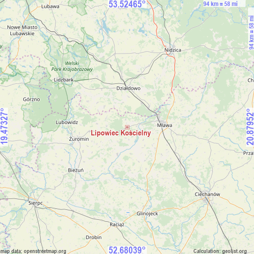
Lipowiec Kościelny GPS coordinates[2]
53° 6' 16.524" North, 20° 10' 35.004" East
| Map corner | latitude | longitude |
|---|---|---|
| Upper-left | 53.52465°, | 19.47327° |
| Center: | 53.10459°, | 20.17639° |
| Lower-right: | 52.68039°, | 20.87952° |
| Map W x H: | 93.9×93.9 km | = 58.3×58.3mi |
| max Lat: | 54.83135° ⇑14.9% North |
| Lipowiec Kościelny: | 53.10459° |
| min Lat: | ⇓85.1% South 49.21328° |
| min Long | Lipowiec Kości | max Long |
| 14.20249° | 20.17639° | 24.03723° |
| W 61%⇐ | ⇒39% E |
Elevation
Elevation of Lipowiec Kościelny is 135 m = 443 ft, and this is 56.4 m = 185 ft below average elevation for this country.
| Max E: |
974 m = 3196 ft | 64.4% |
| Avg. | 191.4 m = 628 ft | |
| Lipowiec Kościelny | 135 m = 443 ft | |
Min E: |
-3 m = -10 ft | 35.6% |
See also: Poland elevation on elevation.city.
Geographical zone
Lipowiec Kościelny is located in North temperate zone (between Tropic of Cancer and the Arctic Circle). Distance of this North polar circle is 1496.5 km =929.9 mi to North.| Distance of | km | miles | from Lipowiec Kościelny |
|---|---|---|---|
| North Pole | 4102.4 | 2549.1 | to North |
| Arctic Circle | 1496.5 | 929.9 | to North |
| Tropic Cancer | 3298.8 | 2049.8 | to South |
| Equator | 5904.7 | 3669 | to South |


Nearby cities:
15 places around Lipowiec Kościelny: (largest is in red/bold)
• Działdowo
15 km =9.3 mi,  358°
358°
• Iłowo -Osada
10.5 km =6.5 mi,  47°
47°
• Kozłowo
23.7 km =14.7 mi,  18°
18°
• Kuczbork-Osada
8.8 km =5.5 mi,  256°
256°
• Kuczbork-Wieś
9.2 km =5.7 mi,  254°
254°
• Lubowidz
22.1 km =13.7 mi,  274°
274°
• Mława
13.9 km =8.6 mi,  86°
86°
• Płośnica
21.6 km =13.4 mi,  329°
329°
• Radzanów
18.9 km =11.7 mi,  197°
197°
• Stupsk
19.6 km =12.2 mi,  117°
117°
• Szreńsk
10.9 km =6.8 mi, 200°
• Szydłowo
18.5 km =11.5 mi,  98°
98°
• Wieczfnia Kościelna
22.4 km =13.9 mi,  63°
63°
• Wiśniewo
12.3 km =7.6 mi,  111°
111°
• Żuromin
18.4 km =11.4 mi, 256°
Sources, notices
• [Note1] Compared only with cities in Poland existing in our database
• [Src1] Map data: © OpenStreetMap contributors (CC-BY-SA)
• [Src2] Other city data from geonames.org with taken over terms of usage.
• [Src3] Geographical zone / Annual Mean Temperature by Robert A. Rohde @ Wikipedia
