Szreńsk geodata
Szreńsk (Mazovia) is a seat of a third-order administrative division; located in Poland in Europe/Warsaw (GMT+2) time zone. With population of 1,200 people, there are 2164 cities with bigger population in this country. Compared to other cities in Poland, 83.7% of cities are located further ↓South; 60.4% of cities are located further ←West and 73.1% of cities have higher elevation than Szreńsk. Note1


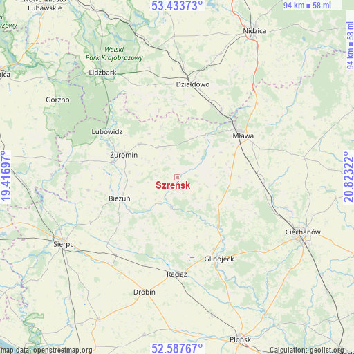
Szreńsk GPS coordinates[2]
53° 0' 45.972" North, 20° 7' 12.324" East
| Map corner | latitude | longitude |
|---|---|---|
| Upper-left | 53.43373°, | 19.41697° |
| Center: | 53.01277°, | 20.12009° |
| Lower-right: | 52.58767°, | 20.82322° |
| Map W x H: | 94.1×94.1 km | = 58.5×58.5mi |
| max Lat: | 54.83135° ⇑16.3% North |
| Szreńsk: | 53.01277° |
| min Lat: | ⇓83.7% South 49.21328° |
| min Long | Szreńsk | max Long |
| 14.20249° | 20.12009° | 24.03723° |
| W 60.4%⇐ | ⇒39.6% E |
Elevation
Elevation of Szreńsk is 115 m = 377 ft, and this is 76.4 m = 251 ft below average elevation for this country.
| Max E: |
974 m = 3196 ft | 73.1% |
| Avg. | 191.4 m = 628 ft | |
| Szreńsk | 115 m = 377 ft | |
Min E: |
-3 m = -10 ft | 26.9% |
See also: Poland elevation on elevation.city.
Geographical zone
Szreńsk is located in North temperate zone (between Tropic of Cancer and the Arctic Circle). Distance of this North polar circle is 1506.7 km =936.2 mi to North.| Distance of | km | miles | from Szreńsk |
|---|---|---|---|
| North Pole | 4112.6 | 2555.5 | to North |
| Arctic Circle | 1506.7 | 936.2 | to North |
| Tropic Cancer | 3288.5 | 2043.4 | to South |
| Equator | 5894.5 | 3662.7 | to South |


Nearby cities:
15 places around Szreńsk: (largest is in red/bold)
• Bieżuń
16.5 km =10.3 mi,  249°
249°
• Iłowo -Osada
20.8 km =12.9 mi,  33°
33°
• Kuczbork-Osada
9.5 km =5.9 mi,  329°
329°
• Kuczbork-Wieś
9.4 km =5.8 mi, 326°
• Lipowiec Kościelny
10.9 km =6.8 mi,  20°
20°
• Lubowidz
21.8 km =13.5 mi,  302°
302°
• Lutocin
23.9 km =14.9 mi,  261°
261°
• Mława
20.9 km =13 mi,  57°
57°
• Radzanów
8 km =5 mi,  193°
193°
• Siemiątkowo
15.9 km =9.9 mi,  202°
202°
• Strzegowo
17.2 km =10.7 mi,  140°
140°
• Stupsk
21.2 km =13.2 mi,  87°
87°
• Szydłowo
23.4 km =14.5 mi,  71°
71°
• Wiśniewo
16.3 km =10.1 mi, 69°
• Żuromin
15.3 km =9.5 mi,  292°
292°
Sources, notices
• [Note1] Compared only with cities in Poland existing in our database
• [Src1] Map data: © OpenStreetMap contributors (CC-BY-SA)
• [Src2] Other city data from geonames.org with taken over terms of usage.
• [Src3] Geographical zone / Annual Mean Temperature by Robert A. Rohde @ Wikipedia
