Kuczbork-Wieś geodata
Kuczbork-Wieś (Mazovia) is a populated place; located in Poland in Europe/Warsaw (GMT+2) time zone. With population of 626 people, there are 3220 cities with bigger population in this country. Compared to other cities in Poland, 84.6% of cities are located further ↓South; 59% of cities are located further ←West and 66.4% of cities have higher elevation than Kuczbork-Wieś. Note1


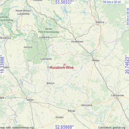
Kuczbork-Wieś GPS coordinates[2]
53° 4' 59.16" North, 20° 2' 35.16" East
| Map corner | latitude | longitude |
|---|---|---|
| Upper-left | 53.50337°, | 19.33998° |
| Center: | 53.0831°, | 20.0431° |
| Lower-right: | 52.65869°, | 20.74623° |
| Map W x H: | 93.9×93.9 km | = 58.3×58.3mi |
| max Lat: | 54.83135° ⇑15.4% North |
| Kuczbork-Wieś: | 53.0831° |
| min Lat: | ⇓84.6% South 49.21328° |
| min Long | Kuczbork-Wieś | max Long |
| 14.20249° | 20.0431° | 24.03723° |
| W 59%⇐ | ⇒41% E |
Elevation
Elevation of Kuczbork-Wieś is 129 m = 423 ft, and this is 62.4 m = 205 ft below average elevation for this country.
| Max E: |
974 m = 3196 ft | 66.4% |
| Avg. | 191.4 m = 628 ft | |
| Kuczbork-Wieś | 129 m = 423 ft | |
Min E: |
-3 m = -10 ft | 33.6% |
See also: Poland elevation on elevation.city.
Geographical zone
Kuczbork-Wieś is located in North temperate zone (between Tropic of Cancer and the Arctic Circle). Distance of this North polar circle is 1498.9 km =931.4 mi to North.| Distance of | km | miles | from Kuczbork-Wieś |
|---|---|---|---|
| North Pole | 4104.8 | 2550.6 | to North |
| Arctic Circle | 1498.9 | 931.4 | to North |
| Tropic Cancer | 3296.4 | 2048.3 | to South |
| Equator | 5902.3 | 3667.5 | to South |


Nearby cities:
15 places around Kuczbork-Wieś: (largest is in red/bold)
• Bieżuń
17 km =10.6 mi,  217°
217°
• Działdowo
19.3 km =12 mi,  25°
25°
• Iłowo -Osada
19.2 km =11.9 mi,  60°
60°
• Kuczbork-Osada
0.5 km =0.3 mi,  42°
42°
• Lidzbark
24.6 km =15.3 mi,  324°
324°
• Lipowiec Kościelny
9.2 km =5.7 mi,  74°
74°
• Lubowidz
13.7 km =8.5 mi,  286°
286°
• Lutocin
21.7 km =13.5 mi,  238°
238°
• Mława
23 km =14.3 mi,  81°
81°
• Płośnica
21.1 km =13.1 mi,  354°
354°
• Radzanów
16 km =9.9 mi,  168°
168°
• Siemiątkowo
22.5 km =14 mi,  182°
182°
• Szreńsk
9.4 km =5.8 mi,  146°
146°
• Wiśniewo
20.5 km =12.7 mi,  95°
95°
• Żuromin
9.2 km =5.7 mi,  258°
258°
Sources, notices
• [Note1] Compared only with cities in Poland existing in our database
• [Src1] Map data: © OpenStreetMap contributors (CC-BY-SA)
• [Src2] Other city data from geonames.org with taken over terms of usage.
• [Src3] Geographical zone / Annual Mean Temperature by Robert A. Rohde @ Wikipedia
