Bachowice geodata
Bachowice (Lesser Poland) is a populated place; located in Poland in Europe/Warsaw (GMT+2) time zone. With population of 2,234 people, there are 1343 cities with bigger population in this country. Compared to other cities in Poland, 85% of cities are located further ↑North; 51% of cities are located further →East and 86.4% of cities have lower elevation than Bachowice. Note1


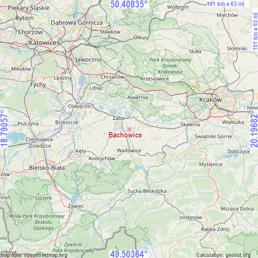
Bachowice GPS coordinates[2]
49° 57' 29.232" North, 19° 29' 37.284" East
| Map corner | latitude | longitude |
|---|---|---|
| Upper-left | 50.40835°, | 18.79057° |
| Center: | 49.95812°, | 19.49369° |
| Lower-right: | 49.50364°, | 20.19682° |
| Map W x H: | 100.6×100.6 km | = 62.5×62.5mi |
| max Lat: | 54.83135° ⇑85% North |
| Bachowice: | 49.95812° |
| min Lat: | ⇓15% South 49.21328° |
| min Long | Bachowice | max Long |
| 14.20249° | 19.49369° | 24.03723° |
| W 49%⇐ | ⇒51% E |
Elevation
Elevation of Bachowice is 298 m = 978 ft, and this is 106.6 m = 350 ft above average elevation for this country.
| Max E: |
974 m = 3196 ft | 13.6% |
| Bachowice | 298 m 978 ft | |
| Avg. | 191.4 m = 628 ft | |
Min E: |
-3 m = -10 ft | 86.4% |
See also: Poland elevation on elevation.city.
Geographical zone
Bachowice is located in North temperate zone (between Tropic of Cancer and the Arctic Circle). Distance of this North polar circle is 1846.4 km =1147.3 mi to North.| Distance of | km | miles | from Bachowice |
|---|---|---|---|
| North Pole | 4452.2 | 2766.5 | to North |
| Arctic Circle | 1846.4 | 1147.3 | to North |
| Tropic Cancer | 2948.9 | 1832.4 | to South |
| Equator | 5554.8 | 3451.6 | to South |


Nearby cities:
15 places around Bachowice: (largest is in red/bold)
• Frydrychowice
8 km =5 mi,  221°
221°
• Gierałtowice
7.5 km =4.7 mi,  258°
258°
• Graboszyce
3.5 km =2.2 mi,  246°
246°
• Kamień
8.9 km =5.5 mi,  47°
47°
• Marcyporęba
8.7 km =5.4 mi,  99°
99°
• Okleśna
8.5 km =5.3 mi,  18°
18°
• Radocza
4.7 km =2.9 mi,  196°
196°
• Ryczów
4.8 km =3 mi,  57°
57°
• Spytkowice
4.5 km =2.8 mi, 16°
• Tomice
6.8 km =4.2 mi,  186°
186°
• Wadowice
8.3 km =5.2 mi,  180°
180°
• Witanowice
5 km =3.1 mi,  152°
152°
• Woźniki
2.3 km =1.4 mi, 185°
• Zator
5.8 km =3.6 mi,  316°
316°
• Łączany
6.7 km =4.2 mi, 64°
Sources, notices
• [Note1] Compared only with cities in Poland existing in our database
• [Src1] Map data: © OpenStreetMap contributors (CC-BY-SA)
• [Src2] Other city data from geonames.org with taken over terms of usage.
• [Src3] Geographical zone / Annual Mean Temperature by Robert A. Rohde @ Wikipedia
