Kwaczała geodata
Kwaczała (Lesser Poland) is a populated place; located in Poland in Europe/Warsaw (GMT+2) time zone. With population of 1,857 people, there are 1580 cities with bigger population in this country. Compared to other cities in Poland, 79.4% of cities are located further ↑North; 51% of cities are located further →East and 76.3% of cities have lower elevation than Kwaczała. Note1


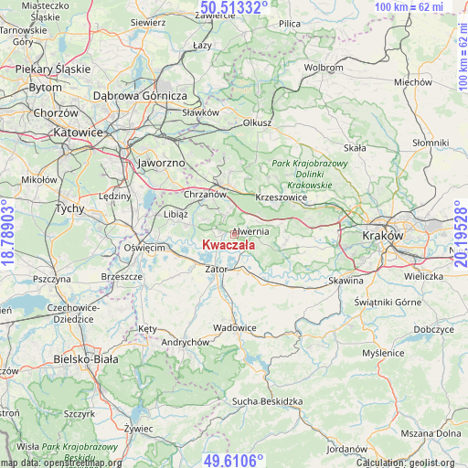
Kwaczała GPS coordinates[2]
50° 3' 50.688" North, 19° 29' 31.74" East
| Map corner | latitude | longitude |
|---|---|---|
| Upper-left | 50.51332°, | 18.78903° |
| Center: | 50.06408°, | 19.49215° |
| Lower-right: | 49.6106°, | 20.19528° |
| Map W x H: | 100.4×100.4 km | = 62.4×62.4mi |
| max Lat: | 54.83135° ⇑79.4% North |
| Kwaczała: | 50.06408° |
| min Lat: | ⇓20.6% South 49.21328° |
| min Long | Kwaczała | max Long |
| 14.20249° | 19.49215° | 24.03723° |
| W 49%⇐ | ⇒51% E |
Elevation
Elevation of Kwaczała is 251 m = 823 ft, and this is 59.6 m = 196 ft above average elevation for this country.
| Max E: |
974 m = 3196 ft | 23.7% |
| Kwaczała | 251 m 823 ft | |
| Avg. | 191.4 m = 628 ft | |
Min E: |
-3 m = -10 ft | 76.3% |
See also: Poland elevation on elevation.city.
Geographical zone
Kwaczała is located in North temperate zone (between Tropic of Cancer and the Arctic Circle). Distance of this North polar circle is 1834.6 km =1140 mi to North.| Distance of | km | miles | from Kwaczała |
|---|---|---|---|
| North Pole | 4440.5 | 2759.2 | to North |
| Arctic Circle | 1834.6 | 1140 | to North |
| Tropic Cancer | 2960.7 | 1839.7 | to South |
| Equator | 5566.6 | 3458.9 | to South |


Nearby cities:
15 places around Kwaczała: (largest is in red/bold)
• Alwernia
3.4 km =2.1 mi,  96°
96°
• Babice
3.1 km =1.9 mi,  279°
279°
• Bolęcin
6 km =3.7 mi,  352°
352°
• Brodła
7.3 km =4.5 mi,  108°
108°
• Grojec
5.4 km =3.4 mi,  58°
58°
• Jankowice
4.2 km =2.6 mi,  238°
238°
• Okleśna
4.6 km =2.9 mi,  142°
142°
• Olszyny
3.1 km =1.9 mi,  246°
246°
• Pogorzyce
6.5 km =4 mi,  310°
310°
• Płaza
4.4 km =2.7 mi,  333°
333°
• Regulice
3.3 km =2.1 mi,  50°
50°
• Rozkochów
2.1 km =1.3 mi,  183°
183°
• Rudno
7.2 km =4.5 mi, 57°
• Spytkowice
7.6 km =4.7 mi,  169°
169°
• Zagórze
7.2 km =4.5 mi,  298°
298°
Sources, notices
• [Note1] Compared only with cities in Poland existing in our database
• [Src1] Map data: © OpenStreetMap contributors (CC-BY-SA)
• [Src2] Other city data from geonames.org with taken over terms of usage.
• [Src3] Geographical zone / Annual Mean Temperature by Robert A. Rohde @ Wikipedia
