Lubiszyn geodata
Lubiszyn (Lubusz) is a seat of a third-order administrative division; located in Poland in Europe/Warsaw (GMT+2) time zone. With population of 800 people, there are 2851 cities with bigger population in this country. Compared to other cities in Poland, 80.6% of cities are located further ↓South; 98.3% of cities are located further →East and 93.8% of cities have higher elevation than Lubiszyn. Note1


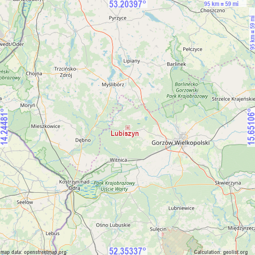
Lubiszyn GPS coordinates[2]
52° 46' 50.7" North, 14° 56' 52.548" East
| Map corner | latitude | longitude |
|---|---|---|
| Upper-left | 53.20397°, | 14.24481° |
| Center: | 52.78075°, | 14.94793° |
| Lower-right: | 52.35337°, | 15.65106° |
| Map W x H: | 94.6×94.6 km | = 58.8×58.8mi |
| max Lat: | 54.83135° ⇑19.4% North |
| Lubiszyn: | 52.78075° |
| min Lat: | ⇓80.6% South 49.21328° |
| min Long | Lubiszyn | max Long |
| 14.20249° | 14.94793° | 24.03723° |
| W 1.7%⇐ | ⇒98.3% E |
Elevation
Elevation of Lubiszyn is 55 m = 180 ft, and this is 136.4 m = 448 ft below average elevation for this country.
| Max E: |
974 m = 3196 ft | 93.8% |
| Avg. | 191.4 m = 628 ft | |
| Lubiszyn | 55 m = 180 ft | |
Min E: |
-3 m = -10 ft | 6.2% |
See also: Poland elevation on elevation.city.
Geographical zone
Lubiszyn is located in North temperate zone (between Tropic of Cancer and the Arctic Circle). Distance of this North polar circle is 1532.5 km =952.3 mi to North.| Distance of | km | miles | from Lubiszyn |
|---|---|---|---|
| North Pole | 4138.4 | 2571.5 | to North |
| Arctic Circle | 1532.5 | 952.3 | to North |
| Tropic Cancer | 3262.8 | 2027.4 | to South |
| Equator | 5868.7 | 3646.6 | to South |


Nearby cities:
15 places around Lubiszyn: (largest is in red/bold)
• Baczyna
11.6 km =7.2 mi,  104°
104°
• Bogdaniec
13.2 km =8.2 mi,  140°
140°
• Cychry
19 km =11.8 mi,  239°
239°
• Dargomyśl
21.9 km =13.6 mi,  247°
247°
• Dębno
17.4 km =10.8 mi, 254°
• Gorzów Wielkopolski
19.5 km =12.1 mi, 104°
• Jenin
13.8 km =8.6 mi,  132°
132°
• Kłodawa
17.9 km =11.1 mi,  88°
88°
• Myślibórz
16.8 km =10.4 mi,  341°
341°
• Nowogródek Pomorski
15.5 km =9.6 mi,  20°
20°
• Oborzany
19.6 km =12.2 mi,  256°
256°
• Trzcinna
12.1 km =7.5 mi, 20°
• Witnica
12.4 km =7.7 mi,  195°
195°
• Wysoka
6.1 km =3.8 mi, 94°
• Łupowo
14.5 km =9 mi, 126°
Sources, notices
• [Note1] Compared only with cities in Poland existing in our database
• [Src1] Map data: © OpenStreetMap contributors (CC-BY-SA)
• [Src2] Other city data from geonames.org with taken over terms of usage.
• [Src3] Geographical zone / Annual Mean Temperature by Robert A. Rohde @ Wikipedia
