Trzcinna geodata
Trzcinna (West Pomerania) is a populated place; located in Poland in Europe/Warsaw (GMT+2) time zone. With population of 523 people, there are 3473 cities with bigger population in this country. Compared to other cities in Poland, 82.1% of cities are located further ↓South; 98% of cities are located further →East and 91.3% of cities have higher elevation than Trzcinna. Note1
Administrative division(s):
- Level 1: West Pomerania
- Level 2: Powiat myśliborski
- Level 3: Nowogródek Pomorski


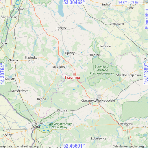
Trzcinna GPS coordinates[2]
52° 52' 56.604" North, 15° 0' 38.736" East
| Map corner | latitude | longitude |
|---|---|---|
| Upper-left | 53.30462°, | 14.30764° |
| Center: | 52.88239°, | 15.01076° |
| Lower-right: | 52.45601°, | 15.71389° |
| Map W x H: | 94.4×94.4 km | = 58.7×58.7mi |
| max Lat: | 54.83135° ⇑17.9% North |
| Trzcinna: | 52.88239° |
| min Lat: | ⇓82.1% South 49.21328° |
| min Long | Trzcinna | max Long |
| 14.20249° | 15.01076° | 24.03723° |
| W 2%⇐ | ⇒98% E |
Elevation
Elevation of Trzcinna is 69 m = 226 ft, and this is 122.4 m = 402 ft below average elevation for this country.
| Max E: |
974 m = 3196 ft | 91.3% |
| Avg. | 191.4 m = 628 ft | |
| Trzcinna | 69 m = 226 ft | |
Min E: |
-3 m = -10 ft | 8.7% |
See also: Poland elevation on elevation.city.
Geographical zone
Trzcinna is located in North temperate zone (between Tropic of Cancer and the Arctic Circle). Distance of this North polar circle is 1521.2 km =945.2 mi to North.| Distance of | km | miles | from Trzcinna |
|---|---|---|---|
| North Pole | 4127.1 | 2564.5 | to North |
| Arctic Circle | 1521.2 | 945.2 | to North |
| Tropic Cancer | 3274.1 | 2034.4 | to South |
| Equator | 5880 | 3653.7 | to South |


Nearby cities:
15 places around Trzcinna: (largest is in red/bold)
• Baczyna
15.8 km =9.8 mi,  153°
153°
• Barlinek
18.7 km =11.6 mi,  48°
48°
• Bogdaniec
21.9 km =13.6 mi,  169°
169°
• Gorzów Wielkopolski
21.8 km =13.5 mi,  137°
137°
• Jenin
21.5 km =13.4 mi,  164°
164°
• Kłodawa
17.4 km =10.8 mi,  128°
128°
• Lipiany
13.7 km =8.5 mi,  348°
348°
• Lubiszyn
12.1 km =7.5 mi,  200°
200°
• Mostkowo
12.7 km =7.9 mi,  14°
14°
• Myślibórz
10.6 km =6.6 mi,  295°
295°
• Nowogródek Pomorski
3.5 km =2.2 mi,  21°
21°
• Przelewice
25 km =15.5 mi, 10°
• Witnica
24.5 km =15.2 mi, 198°
• Wysoka
11.9 km =7.4 mi, 171°
• Łupowo
21.3 km =13.2 mi, 159°
Sources, notices
• [Note1] Compared only with cities in Poland existing in our database
• [Src1] Map data: © OpenStreetMap contributors (CC-BY-SA)
• [Src2] Other city data from geonames.org with taken over terms of usage.
• [Src3] Geographical zone / Annual Mean Temperature by Robert A. Rohde @ Wikipedia
