Nowogródek Pomorski geodata
Nowogródek Pomorski (West Pomerania) is a seat of a third-order administrative division; located in Poland in Europe/Warsaw (GMT+2) time zone. With population of 450 people, there are 3564 cities with bigger population in this country. Compared to other cities in Poland, 82.6% of cities are located further ↓South; 97.9% of cities are located further →East and 90.4% of cities have higher elevation than Nowogródek Pomorski. Note1
Administrative division(s):
- Level 1: West Pomerania
- Level 2: Powiat myśliborski
- Level 3: Nowogródek Pomorski


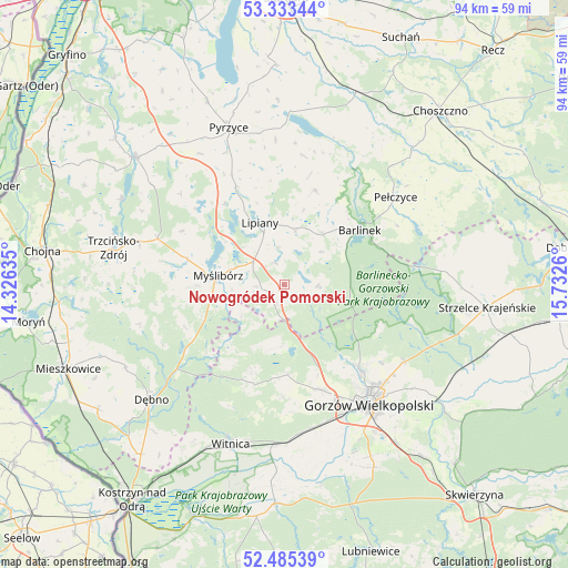
Nowogródek Pomorski GPS coordinates[2]
52° 54' 41.364" North, 15° 1' 46.092" East
| Map corner | latitude | longitude |
|---|---|---|
| Upper-left | 53.33344°, | 14.32635° |
| Center: | 52.91149°, | 15.02947° |
| Lower-right: | 52.48539°, | 15.7326° |
| Map W x H: | 94.3×94.3 km | = 58.6×58.6mi |
| max Lat: | 54.83135° ⇑17.4% North |
| Nowogródek Pomorski: | 52.91149° |
| min Lat: | ⇓82.6% South 49.21328° |
| min Long | Nowogródek Pom | max Long |
| 14.20249° | 15.02947° | 24.03723° |
| W 2.1%⇐ | ⇒97.9% E |
Elevation
Elevation of Nowogródek Pomorski is 73 m = 240 ft, and this is 118.4 m = 388 ft below average elevation for this country.
| Max E: |
974 m = 3196 ft | 90.4% |
| Avg. | 191.4 m = 628 ft | |
| Nowogródek Pomorski | 73 m = 240 ft | |
Min E: |
-3 m = -10 ft | 9.6% |
See also: Poland elevation on elevation.city.
Geographical zone
Nowogródek Pomorski is located in North temperate zone (between Tropic of Cancer and the Arctic Circle). Distance of this North polar circle is 1518 km =943.2 mi to North.| Distance of | km | miles | from Nowogródek Pomorski |
|---|---|---|---|
| North Pole | 4123.9 | 2562.5 | to North |
| Arctic Circle | 1518 | 943.2 | to North |
| Tropic Cancer | 3277.3 | 2036.4 | to South |
| Equator | 5883.2 | 3655.6 | to South |


Nearby cities:
15 places around Nowogródek Pomorski: (largest is in red/bold)
• Baczyna
18.3 km =11.4 mi,  161°
161°
• Barlinek
15.7 km =9.8 mi,  53°
53°
• Bogdaniec
24.9 km =15.5 mi,  173°
173°
• Gorzów Wielkopolski
23.6 km =14.7 mi,  145°
145°
• Jenin
24.3 km =15.1 mi, 169°
• Kłodawa
18.7 km =11.6 mi,  138°
138°
• Lipiany
11 km =6.8 mi,  338°
338°
• Lubiszyn
15.5 km =9.6 mi,  200°
200°
• Mostkowo
9.2 km =5.7 mi,  11°
11°
• Myślibórz
10.9 km =6.8 mi,  277°
277°
• Pełczyce
23.5 km =14.6 mi, 51°
• Przelewice
21.6 km =13.4 mi, 8°
• Trzcinna
3.5 km =2.2 mi, 201°
• Wysoka
15 km =9.3 mi,  177°
177°
• Łupowo
24.1 km =15 mi, 165°
Sources, notices
• [Note1] Compared only with cities in Poland existing in our database
• [Src1] Map data: © OpenStreetMap contributors (CC-BY-SA)
• [Src2] Other city data from geonames.org with taken over terms of usage.
• [Src3] Geographical zone / Annual Mean Temperature by Robert A. Rohde @ Wikipedia
