Sypniewo geodata
Sypniewo (Kujawsko-Pomorskie) is a populated place; located in Poland in Europe/Warsaw (GMT+2) time zone. With population of 1,300 people, there are 2055 cities with bigger population in this country. Compared to other cities in Poland, 88.2% of cities are located further ↓South; 81.3% of cities are located further →East and 65.6% of cities have higher elevation than Sypniewo. Note1
Administrative division(s):
- Level 1: Kujawsko-Pomorskie
- Level 2: Powiat sępoleński
- Level 3: Więcbork


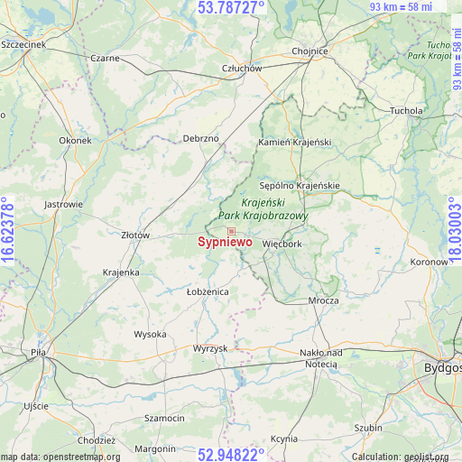
Sypniewo GPS coordinates[2]
53° 22' 11.316" North, 17° 19' 36.84" East
| Map corner | latitude | longitude |
|---|---|---|
| Upper-left | 53.78727°, | 16.62378° |
| Center: | 53.36981°, | 17.3269° |
| Lower-right: | 52.94822°, | 18.03003° |
| Map W x H: | 93.3×93.3 km | = 58×58mi |
| max Lat: | 54.83135° ⇑11.8% North |
| Sypniewo: | 53.36981° |
| min Lat: | ⇓88.2% South 49.21328° |
| min Long | Sypniewo | max Long |
| 14.20249° | 17.3269° | 24.03723° |
| W 18.7%⇐ | ⇒81.3% E |
Elevation
Elevation of Sypniewo is 131 m = 430 ft, and this is 60.4 m = 198 ft below average elevation for this country.
| Max E: |
974 m = 3196 ft | 65.6% |
| Avg. | 191.4 m = 628 ft | |
| Sypniewo | 131 m = 430 ft | |
Min E: |
-3 m = -10 ft | 34.4% |
See also: Poland elevation on elevation.city.
Geographical zone
Sypniewo is located in North temperate zone (between Tropic of Cancer and the Arctic Circle). Distance of this North polar circle is 1467 km =911.6 mi to North.| Distance of | km | miles | from Sypniewo |
|---|---|---|---|
| North Pole | 4072.9 | 2530.8 | to North |
| Arctic Circle | 1467 | 911.6 | to North |
| Tropic Cancer | 3328.2 | 2068 | to South |
| Equator | 5934.2 | 3687.3 | to South |


Nearby cities:
15 places around Sypniewo: (largest is in red/bold)
• Debrzno
19.7 km =12.2 mi,  342°
342°
• Kamień Krajeński
22.3 km =13.9 mi,  35°
35°
• Krajenka
23.7 km =14.7 mi,  250°
250°
• Lipka
14.9 km =9.3 mi, 340°
• Mrocza
23.2 km =14.4 mi,  127°
127°
• Osiek nad Notecią
27.8 km =17.3 mi,  184°
184°
• Sadki
24.7 km =15.3 mi,  160°
160°
• Sośno
24 km =14.9 mi,  84°
84°
• Sępólno Krajeńskie
16.4 km =10.2 mi,  56°
56°
• Więcbork
11 km =6.8 mi,  99°
99°
• Wyrzysk
24.4 km =15.2 mi,  189°
189°
• Wysoka
26.5 km =16.5 mi,  217°
217°
• Zakrzewo
12.3 km =7.6 mi,  292°
292°
• Złotów
19 km =11.8 mi,  267°
267°
• Łobżenica
12.8 km =8 mi,  201°
201°
Sources, notices
• [Note1] Compared only with cities in Poland existing in our database
• [Src1] Map data: © OpenStreetMap contributors (CC-BY-SA)
• [Src2] Other city data from geonames.org with taken over terms of usage.
• [Src3] Geographical zone / Annual Mean Temperature by Robert A. Rohde @ Wikipedia
