Wodzierady geodata
Wodzierady (Łódź Voivodeship) is a seat of a third-order administrative division; located in Poland in Europe/Warsaw (GMT+2) time zone. With population of 239 people, there are 3637 cities with bigger population in this country. Compared to other cities in Poland, 60.5% of cities are located further ↓South; 57.1% of cities are located further →East and 54.2% of cities have higher elevation than Wodzierady. Note1


Wodzierady GPS coordinates[2]
51° 43' 5.736" North, 19° 9' 4.428" East
| Map corner | latitude | longitude |
|---|---|---|
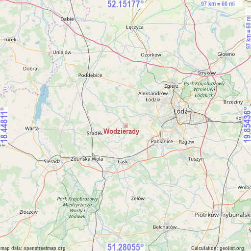
| Upper-left | 52.15177°, | 18.44811° |
| Center: | 51.71826°, | 19.15123° |
| Lower-right: | 51.28055°, | 19.85436° |
| Map W x H: | 96.9×96.9 km | = 60.2×60.2mi |
| max Lat: | 54.83135° ⇑39.5% North |
| Wodzierady: | 51.71826° |
| min Lat: | ⇓60.5% South 49.21328° |
| min Long | Wodzierady | max Long |
| 14.20249° | 19.15123° | 24.03723° |
| W 42.9%⇐ | ⇒57.1% E |
Elevation
Elevation of Wodzierady is 161 m = 528 ft, and this is 30.4 m = 100 ft below average elevation for this country.
| Max E: |
974 m = 3196 ft | 54.2% |
| Avg. | 191.4 m = 628 ft | |
| Wodzierady | 161 m = 528 ft | |
Min E: |
-3 m = -10 ft | 45.8% |
See also: Poland elevation on elevation.city.
Geographical zone
Wodzierady is located in North temperate zone (between Tropic of Cancer and the Arctic Circle). Distance of this North polar circle is 1650.6 km =1025.6 mi to North.| Distance of | km | miles | from Wodzierady |
|---|---|---|---|
| North Pole | 4256.5 | 2644.9 | to North |
| Arctic Circle | 1650.6 | 1025.6 | to North |
| Tropic Cancer | 3144.6 | 1954 | to South |
| Equator | 5750.5 | 3573.2 | to South |


Nearby cities:
15 places around Wodzierady: (largest is in red/bold)
• Aleksandrów Łódzki
15.4 km =9.6 mi,  42°
42°
• Dalików
18.6 km =11.6 mi,  353°
353°
• Dobroń
11 km =6.8 mi,  143°
143°
• Kazimierz
6.7 km =4.2 mi,  34°
34°
• Konstantynów Łódzki
12.5 km =7.8 mi,  74°
74°
• Ksawerów
17.8 km =11.1 mi,  102°
102°
• Lutomiersk
5.7 km =3.5 mi,  46°
46°
• Pabianice
15.2 km =9.4 mi,  113°
113°
• Starowa Góra
23.1 km =14.4 mi, 97°
• Szadek
12.5 km =7.8 mi,  256°
256°
• Wojsławice
17.3 km =10.7 mi,  245°
245°
• Zadzim
21.8 km =13.5 mi,  287°
287°
• Zduńska Wola
19.7 km =12.2 mi,  227°
227°
• Łask
14.3 km =8.9 mi,  185°
185°
• Łódź
23 km =14.3 mi,  75°
75°
Sources, notices
• [Note1] Compared only with cities in Poland existing in our database
• [Src1] Map data: © OpenStreetMap contributors (CC-BY-SA)
• [Src2] Other city data from geonames.org with taken over terms of usage.
• [Src3] Geographical zone / Annual Mean Temperature by Robert A. Rohde @ Wikipedia
