Łódź geodata
Łódź (Łódź Voivodeship) is a seat of a first-order administrative division; located in Poland in Europe/Warsaw (GMT+2) time zone. With population of 768,755 people, there is 1 city with bigger population in this country. Compared to other cities in Poland, 61.5% of cities are located further ↓South; 51.5% of cities are located further →East and 68.1% of cities have lower elevation than Łódź. Note1


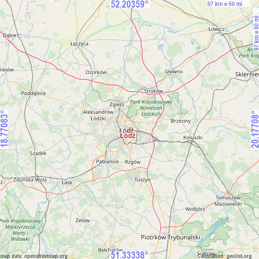
Łódź GPS coordinates[2]
51° 46' 14.088" North, 19° 28' 26.22" East
| Map corner | latitude | longitude |
|---|---|---|
| Upper-left | 52.20359°, | 18.77083° |
| Center: | 51.77058°, | 19.47395° |
| Lower-right: | 51.33338°, | 20.17708° |
| Map W x H: | 96.8×96.8 km | = 60.1×60.1mi |
| max Lat: | 54.83135° ⇑38.5% North |
| Łódź: | 51.77058° |
| min Lat: | ⇓61.5% South 49.21328° |
| min Long | Łódź | max Long |
| 14.20249° | 19.47395° | 24.03723° |
| W 48.5%⇐ | ⇒51.5% E |
Elevation
Elevation of Łódź is 223 m = 732 ft, and this is 31.6 m = 104 ft above average elevation for this country.
| Max E: |
974 m = 3196 ft | 31.9% |
| Łódź | 223 m 732 ft | |
| Avg. | 191.4 m = 628 ft | |
Min E: |
-3 m = -10 ft | 68.1% |
See also: Łódź elevation on elevation.city.
Geographical zone
Łódź is located in North temperate zone (between Tropic of Cancer and the Arctic Circle). Distance of this North polar circle is 1644.8 km =1022 mi to North.| Distance of | km | miles | from Łódź |
|---|---|---|---|
| North Pole | 4250.7 | 2641.3 | to North |
| Arctic Circle | 1644.8 | 1022 | to North |
| Tropic Cancer | 3150.4 | 1957.6 | to South |
| Equator | 5756.3 | 3576.8 | to South |


Nearby cities:
15 places around Łódź: (largest is in red/bold)
• Aleksandrów Łódzki
12.9 km =8 mi,  295°
295°
• Andrespol
12.5 km =7.8 mi,  112°
112°
• Brójce
16.8 km =10.4 mi,  134°
134°
• Dobra
12.6 km =7.8 mi,  28°
28°
• Gałków Duży
17.7 km =11 mi,  102°
102°
• Gałków Mały
17.2 km =10.7 mi, 106°
• Konstantynów Łódzki
10.5 km =6.5 mi,  256°
256°
• Ksawerów
10.9 km =6.8 mi,  206°
206°
• Pabianice
14.4 km =8.9 mi, 214°
• Rzgów
12 km =7.5 mi,  174°
174°
• Starowa Góra
8.8 km =5.5 mi,  175°
175°
• Stryków
17.2 km =10.7 mi, 31°
• Szczawin
14.5 km =9 mi,  3°
3°
• Wola Rakowa
14.4 km =8.9 mi,  138°
138°
• Zgierz
10.5 km =6.5 mi,  333°
333°
Sources, notices
• [Note1] Compared only with cities in Poland existing in our database
• [Src1] Map data: © OpenStreetMap contributors (CC-BY-SA)
• [Src2] Other city data from geonames.org with taken over terms of usage.
• [Src3] Geographical zone / Annual Mean Temperature by Robert A. Rohde @ Wikipedia
