Zadzim geodata
Zadzim (Łódź Voivodeship) is a seat of a third-order administrative division; located in Poland in Europe/Warsaw (GMT+2) time zone. With population of 500 people, there are 3540 cities with bigger population in this country. Compared to other cities in Poland, 61.6% of cities are located further ↓South; 62.6% of cities are located further →East and 62.1% of cities have higher elevation than Zadzim. Note1


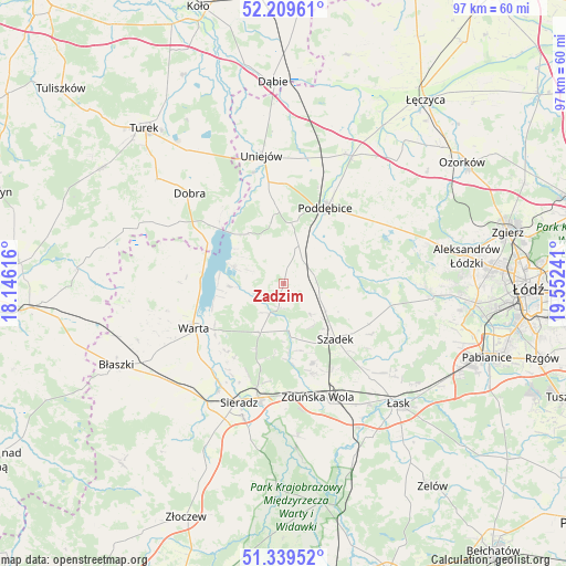
Zadzim GPS coordinates[2]
51° 46' 35.976" North, 18° 50' 57.408" East
| Map corner | latitude | longitude |
|---|---|---|
| Upper-left | 52.20961°, | 18.14616° |
| Center: | 51.77666°, | 18.84928° |
| Lower-right: | 51.33952°, | 19.55241° |
| Map W x H: | 96.7×96.7 km | = 60.1×60.1mi |
| max Lat: | 54.83135° ⇑38.4% North |
| Zadzim: | 51.77666° |
| min Lat: | ⇓61.6% South 49.21328° |
| min Long | Zadzim | max Long |
| 14.20249° | 18.84928° | 24.03723° |
| W 37.4%⇐ | ⇒62.6% E |
Elevation
Elevation of Zadzim is 142 m = 466 ft, and this is 49.4 m = 162 ft below average elevation for this country.
| Max E: |
974 m = 3196 ft | 62.1% |
| Avg. | 191.4 m = 628 ft | |
| Zadzim | 142 m = 466 ft | |
Min E: |
-3 m = -10 ft | 37.9% |
See also: Poland elevation on elevation.city.
Geographical zone
Zadzim is located in North temperate zone (between Tropic of Cancer and the Arctic Circle). Distance of this North polar circle is 1644.1 km =1021.6 mi to North.| Distance of | km | miles | from Zadzim |
|---|---|---|---|
| North Pole | 4250 | 2640.8 | to North |
| Arctic Circle | 1644.1 | 1021.6 | to North |
| Tropic Cancer | 3151.1 | 1958 | to South |
| Equator | 5757 | 3577.2 | to South |


Nearby cities:
15 places around Zadzim: (largest is in red/bold)
• Dalików
22.1 km =13.7 mi,  57°
57°
• Dobra
22.4 km =13.9 mi,  314°
314°
• Goszczanów
23.7 km =14.7 mi,  274°
274°
• Kazimierz
24.6 km =15.3 mi,  92°
92°
• Poddębice
15 km =9.3 mi,  29°
29°
• Pęczniew
9.2 km =5.7 mi,  289°
289°
• Sieradz
21.7 km =13.5 mi,  202°
202°
• Szadek
12.8 km =8 mi,  137°
137°
• Uniejów
22.3 km =13.9 mi,  350°
350°
• Warta
17.1 km =10.6 mi,  244°
244°
• Wartkowice
24.5 km =15.2 mi, 25°
• Wodzierady
21.8 km =13.5 mi,  107°
107°
• Wojsławice
14.7 km =9.1 mi,  159°
159°
• Wróblew
24.4 km =15.2 mi,  221°
221°
• Zduńska Wola
20.7 km =12.9 mi, 162°
Sources, notices
• [Note1] Compared only with cities in Poland existing in our database
• [Src1] Map data: © OpenStreetMap contributors (CC-BY-SA)
• [Src2] Other city data from geonames.org with taken over terms of usage.
• [Src3] Geographical zone / Annual Mean Temperature by Robert A. Rohde @ Wikipedia
