Aleksandrów Łódzki geodata
Aleksandrów Łódzki (Łódź Voivodeship) is a seat of a third-order administrative division; located in Poland in Europe/Warsaw (GMT+2) time zone. With population of 20,292 people, there are 239 cities with bigger population in this country. Compared to other cities in Poland, 62.4% of cities are located further ↓South; 54.4% of cities are located further →East and 58.5% of cities have lower elevation than Aleksandrów Łódzki. Note1
Administrative division(s):
- Level 1: Łódź Voivodeship
- Level 2: Powiat zgierski
- Level 3: Aleksandrów Łódzki


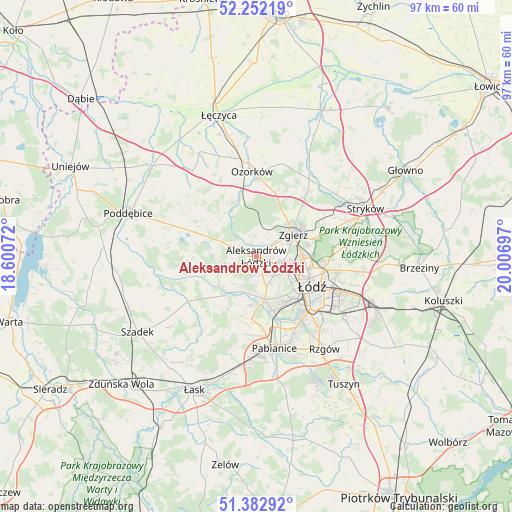
Aleksandrów Łódzki GPS coordinates[2]
51° 49' 10.74" North, 19° 18' 13.824" East
| Map corner | latitude | longitude |
|---|---|---|
| Upper-left | 52.25219°, | 18.60072° |
| Center: | 51.81965°, | 19.30384° |
| Lower-right: | 51.38292°, | 20.00697° |
| Map W x H: | 96.7×96.7 km | = 60.1×60.1mi |
| max Lat: | 54.83135° ⇑37.6% North |
| Aleksandrów Łódzki: | 51.81965° |
| min Lat: | ⇓62.4% South 49.21328° |
| min Long | Aleksandrów Ł | max Long |
| 14.20249° | 19.30384° | 24.03723° |
| W 45.6%⇐ | ⇒54.4% E |
Elevation
Elevation of Aleksandrów Łódzki is 195 m = 640 ft, and this is 3.6 m = 12 ft above average elevation for this country.
| Max E: |
974 m = 3196 ft | 41.5% |
| Aleksandrów Łódzki | 195 m 640 ft | |
| Avg. | 191.4 m = 628 ft | |
Min E: |
-3 m = -10 ft | 58.5% |
See also: Poland elevation on elevation.city.
Geographical zone
Aleksandrów Łódzki is located in North temperate zone (between Tropic of Cancer and the Arctic Circle). Distance of this North polar circle is 1639.4 km =1018.7 mi to North.| Distance of | km | miles | from Aleksandrów Łódzki |
|---|---|---|---|
| North Pole | 4245.3 | 2637.9 | to North |
| Arctic Circle | 1639.4 | 1018.7 | to North |
| Tropic Cancer | 3155.9 | 1961 | to South |
| Equator | 5761.8 | 3580.2 | to South |


Nearby cities:
15 places around Aleksandrów Łódzki: (largest is in red/bold)
• Dalików
14.6 km =9.1 mi,  299°
299°
• Dobra
18.6 km =11.6 mi,  72°
72°
• Dobroń
20.5 km =12.7 mi,  191°
191°
• Kazimierz
8.8 km =5.5 mi,  229°
229°
• Konstantynów Łódzki
8.1 km =5 mi,  169°
169°
• Ksawerów
16.7 km =10.4 mi,  155°
155°
• Lutomiersk
9.7 km =6 mi,  221°
221°
• Ozorków
16 km =9.9 mi,  356°
356°
• Pabianice
17.6 km =10.9 mi, 168°
• Parzęczew
15.8 km =9.8 mi,  334°
334°
• Starowa Góra
18.9 km =11.7 mi,  139°
139°
• Szczawin
15.5 km =9.6 mi,  54°
54°
• Wodzierady
15.4 km =9.6 mi, 222°
• Zgierz
8.1 km =5 mi,  60°
60°
• Łódź
12.9 km =8 mi,  115°
115°
Sources, notices
• [Note1] Compared only with cities in Poland existing in our database
• [Src1] Map data: © OpenStreetMap contributors (CC-BY-SA)
• [Src2] Other city data from geonames.org with taken over terms of usage.
• [Src3] Geographical zone / Annual Mean Temperature by Robert A. Rohde @ Wikipedia
