Budzów geodata
Budzów (Lower Silesia) is a populated place; located in Poland in Europe/Warsaw (GMT+2) time zone. With population of 1,100 people, there are 2307 cities with bigger population in this country. Compared to other cities in Poland, 65.3% of cities are located further ↑North; 87.9% of cities are located further →East and 88.8% of cities have lower elevation than Budzów. Note1


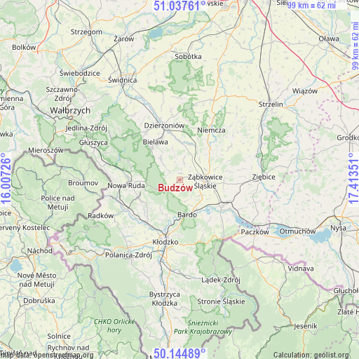
Budzów GPS coordinates[2]
50° 35' 36.132" North, 16° 42' 37.368" East
| Map corner | latitude | longitude |
|---|---|---|
| Upper-left | 51.03761°, | 16.00726° |
| Center: | 50.59337°, | 16.71038° |
| Lower-right: | 50.14489°, | 17.41351° |
| Map W x H: | 99.3×99.3 km | = 61.7×61.7mi |
| max Lat: | 54.83135° ⇑65.3% North |
| Budzów: | 50.59337° |
| min Lat: | ⇓34.7% South 49.21328° |
| min Long | Budzów | max Long |
| 14.20249° | 16.71038° | 24.03723° |
| W 12.1%⇐ | ⇒87.9% E |
Elevation
Elevation of Budzów is 315 m = 1033 ft, and this is 123.6 m = 406 ft above average elevation for this country.
| Max E: |
974 m = 3196 ft | 11.2% |
| Budzów | 315 m 1033 ft | |
| Avg. | 191.4 m = 628 ft | |
Min E: |
-3 m = -10 ft | 88.8% |
See also: Poland elevation on elevation.city.
Geographical zone
Budzów is located in North temperate zone (between Tropic of Cancer and the Arctic Circle). Distance of this North polar circle is 1775.7 km =1103.4 mi to North.| Distance of | km | miles | from Budzów |
|---|---|---|---|
| North Pole | 4381.6 | 2722.6 | to North |
| Arctic Circle | 1775.7 | 1103.4 | to North |
| Tropic Cancer | 3019.5 | 1876.2 | to South |
| Equator | 5625.5 | 3495.5 | to South |


Nearby cities:
15 places around Budzów: (largest is in red/bold)
• Bardo
9.9 km =6.2 mi,  167°
167°
• Bielawa
12.5 km =7.8 mi,  330°
330°
• Bobolice
10.9 km =6.8 mi,  72°
72°
• Bozkow
13.1 km =8.1 mi,  226°
226°
• Brzeźnica
6.1 km =3.8 mi, 165°
• Jodłownik
9 km =5.6 mi,  310°
310°
• Jugów
14.1 km =8.8 mi,  285°
285°
• Kamieniec Ząbkowicki
14.1 km =8.8 mi,  122°
122°
• Nowa Ruda
14.8 km =9.2 mi,  264°
264°
• Ostroszowice
7.7 km =4.8 mi,  319°
319°
• Piława Górna
10.3 km =6.4 mi,  13°
13°
• Przyłęk
9.5 km =5.9 mi,  149°
149°
• Stoszowice
2.1 km =1.3 mi, 70°
• Tarnów
5.9 km =3.7 mi,  106°
106°
• Ząbkowice Śląskie
7.2 km =4.5 mi,  93°
93°
Sources, notices
• [Note1] Compared only with cities in Poland existing in our database
• [Src1] Map data: © OpenStreetMap contributors (CC-BY-SA)
• [Src2] Other city data from geonames.org with taken over terms of usage.
• [Src3] Geographical zone / Annual Mean Temperature by Robert A. Rohde @ Wikipedia
