Bielawa geodata
Bielawa (Lower Silesia) is a populated place; located in Poland in Europe/Warsaw (GMT+2) time zone. With population of 30,824 people, there are 160 cities with bigger population in this country. Compared to other cities in Poland, 62.8% of cities are located further ↑North; 88.6% of cities are located further →East and 86.2% of cities have lower elevation than Bielawa. Note1


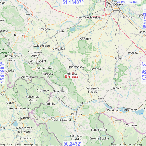
Bielawa GPS coordinates[2]
50° 41' 26.7" North, 16° 37' 22.8" East
| Map corner | latitude | longitude |
|---|---|---|
| Upper-left | 51.13407°, | 15.91988° |
| Center: | 50.69075°, | 16.623° |
| Lower-right: | 50.2432°, | 17.32613° |
| Map W x H: | 99.1×99.1 km | = 61.6×61.6mi |
| max Lat: | 54.83135° ⇑62.8% North |
| Bielawa: | 50.69075° |
| min Lat: | ⇓37.2% South 49.21328° |
| min Long | Bielawa | max Long |
| 14.20249° | 16.623° | 24.03723° |
| W 11.4%⇐ | ⇒88.6% E |
Elevation
Elevation of Bielawa is 297 m = 974 ft, and this is 105.6 m = 346 ft above average elevation for this country.
| Max E: |
974 m = 3196 ft | 13.8% |
| Bielawa | 297 m 974 ft | |
| Avg. | 191.4 m = 628 ft | |
Min E: |
-3 m = -10 ft | 86.2% |
See also: Poland elevation on elevation.city.
Geographical zone
Bielawa is located in North temperate zone (between Tropic of Cancer and the Arctic Circle). Distance of this North polar circle is 1764.9 km =1096.7 mi to North.| Distance of | km | miles | from Bielawa |
|---|---|---|---|
| North Pole | 4370.8 | 2715.9 | to North |
| Arctic Circle | 1764.9 | 1096.7 | to North |
| Tropic Cancer | 3030.4 | 1883 | to South |
| Equator | 5636.3 | 3502.2 | to South |


Nearby cities:
15 places around Bielawa: (largest is in red/bold)
• Budzów
12.5 km =7.8 mi,  150°
150°
• Dobrocin
7.6 km =4.7 mi,  50°
50°
• Dzierżoniów
4.6 km =2.9 mi,  25°
25°
• Jodłownik
5.1 km =3.2 mi,  188°
188°
• Jugów
10.2 km =6.3 mi,  226°
226°
• Ludwikowice Kłodzkie
13.6 km =8.5 mi,  237°
237°
• Niemcza
15.3 km =9.5 mi,  77°
77°
• Nowa Ruda
15 km =9.3 mi,  214°
214°
• Ostroszowice
5.1 km =3.2 mi,  166°
166°
• Pieszyce
3.8 km =2.4 mi,  310°
310°
• Piława Górna
8.5 km =5.3 mi,  95°
95°
• Stoszowice
13 km =8.1 mi,  141°
141°
• Uciechów
8.2 km =5.1 mi, 30°
• Walim
12.6 km =7.8 mi,  273°
273°
• Włodowice
16.5 km =10.3 mi,  218°
218°
Sources, notices
• [Note1] Compared only with cities in Poland existing in our database
• [Src1] Map data: © OpenStreetMap contributors (CC-BY-SA)
• [Src2] Other city data from geonames.org with taken over terms of usage.
• [Src3] Geographical zone / Annual Mean Temperature by Robert A. Rohde @ Wikipedia
