Ostroszowice geodata
Ostroszowice (Lower Silesia) is a populated place; located in Poland in Europe/Warsaw (GMT+2) time zone. With population of 1,303 people, there are 2052 cities with bigger population in this country. Compared to other cities in Poland, 64% of cities are located further ↑North; 88.6% of cities are located further →East and 93.9% of cities have lower elevation than Ostroszowice. Note1
Administrative division(s):
- Level 1: Lower Silesia
- Level 2: Powiat dzierżoniowski
- Level 3: Dzierżoniów


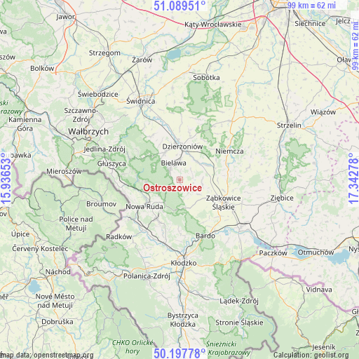
Ostroszowice GPS coordinates[2]
50° 38' 44.736" North, 16° 38' 22.74" East
| Map corner | latitude | longitude |
|---|---|---|
| Upper-left | 51.08951°, | 15.93653° |
| Center: | 50.64576°, | 16.63965° |
| Lower-right: | 50.19778°, | 17.34278° |
| Map W x H: | 99.2×99.1 km | = 61.6×61.6mi |
| max Lat: | 54.83135° ⇑64% North |
| Ostroszowice: | 50.64576° |
| min Lat: | ⇓36% South 49.21328° |
| min Long | Ostroszowice | max Long |
| 14.20249° | 16.63965° | 24.03723° |
| W 11.4%⇐ | ⇒88.6% E |
Elevation
Elevation of Ostroszowice is 387 m = 1270 ft, and this is 195.6 m = 642 ft above average elevation for this country.
| Max E: |
974 m = 3196 ft | 6.1% |
| Ostroszowice | 387 m 1270 ft | |
| Avg. | 191.4 m = 628 ft | |
Min E: |
-3 m = -10 ft | 93.9% |
See also: Poland elevation on elevation.city.
Geographical zone
Ostroszowice is located in North temperate zone (between Tropic of Cancer and the Arctic Circle). Distance of this North polar circle is 1769.9 km =1099.8 mi to North.| Distance of | km | miles | from Ostroszowice |
|---|---|---|---|
| North Pole | 4375.8 | 2719 | to North |
| Arctic Circle | 1769.9 | 1099.8 | to North |
| Tropic Cancer | 3025.4 | 1879.9 | to South |
| Equator | 5631.3 | 3499.1 | to South |


Nearby cities:
15 places around Ostroszowice: (largest is in red/bold)
• Bielawa
5.1 km =3.2 mi,  346°
346°
• Brzeźnica
13.5 km =8.4 mi,  150°
150°
• Budzów
7.7 km =4.8 mi,  139°
139°
• Dobrocin
10.9 km =6.8 mi,  25°
25°
• Dzierżoniów
9.2 km =5.7 mi,  5°
5°
• Jodłownik
1.9 km =1.2 mi,  269°
269°
• Jugów
8.8 km =5.5 mi,  256°
256°
• Ludwikowice Kłodzkie
12.8 km =8 mi, 259°
• Nowa Ruda
12.2 km =7.6 mi,  233°
233°
• Pieszyce
8.5 km =5.3 mi,  331°
331°
• Piława Górna
8.4 km =5.2 mi,  60°
60°
• Stoszowice
8.7 km =5.4 mi,  126°
126°
• Tarnów
13 km =8.1 mi, 125°
• Uciechów
12.5 km =7.8 mi, 13°
• Ząbkowice Śląskie
13.7 km =8.5 mi,  117°
117°
Sources, notices
• [Note1] Compared only with cities in Poland existing in our database
• [Src1] Map data: © OpenStreetMap contributors (CC-BY-SA)
• [Src2] Other city data from geonames.org with taken over terms of usage.
• [Src3] Geographical zone / Annual Mean Temperature by Robert A. Rohde @ Wikipedia
