Witnica geodata
Witnica (West Pomerania) is a populated place; located in Poland in Europe/Warsaw (GMT+2) time zone. With population of 883 people, there are 2706 cities with bigger population in this country. Compared to other cities in Poland, 81.9% of cities are located further ↓South; 99.7% of cities are located further →East and 90.6% of cities have higher elevation than Witnica. Note1


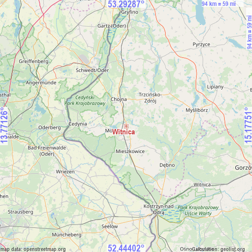
Witnica GPS coordinates[2]
52° 52' 13.872" North, 14° 28' 27.768" East
| Map corner | latitude | longitude |
|---|---|---|
| Upper-left | 53.29287°, | 13.77126° |
| Center: | 52.87052°, | 14.47438° |
| Lower-right: | 52.44402°, | 15.17751° |
| Map W x H: | 94.4×94.4 km | = 58.7×58.7mi |
| max Lat: | 54.83135° ⇑18.1% North |
| Witnica: | 52.87052° |
| min Lat: | ⇓81.9% South 49.21328° |
| min Long | Witnica | max Long |
| 14.20249° | 14.47438° | 24.03723° |
| W 0.3%⇐ | ⇒99.7% E |
Elevation
Elevation of Witnica is 72 m = 236 ft, and this is 119.4 m = 392 ft below average elevation for this country.
| Max E: |
974 m = 3196 ft | 90.6% |
| Avg. | 191.4 m = 628 ft | |
| Witnica | 72 m = 236 ft | |
Min E: |
-3 m = -10 ft | 9.4% |
See also: Poland elevation on elevation.city.
Geographical zone
Witnica is located in North temperate zone (between Tropic of Cancer and the Arctic Circle). Distance of this North polar circle is 1522.5 km =946 mi to North.| Distance of | km | miles | from Witnica |
|---|---|---|---|
| North Pole | 4128.4 | 2565.3 | to North |
| Arctic Circle | 1522.5 | 946 | to North |
| Tropic Cancer | 3272.7 | 2033.6 | to South |
| Equator | 5878.7 | 3652.9 | to South |


Nearby cities:
15 places around Witnica: (largest is in red/bold)
• Banie
28.5 km =17.7 mi,  26°
26°
• Bielin
4.8 km =3 mi,  196°
196°
• Boleszkowice
17.4 km =10.8 mi,  158°
158°
• Cedynia
18.3 km =11.4 mi,  273°
273°
• Chojna
10.8 km =6.7 mi,  343°
343°
• Cychry
25.1 km =15.6 mi,  141°
141°
• Dargomyśl
21.6 km =13.4 mi,  147°
147°
• Dębno
21 km =13 mi,  134°
134°
• Mieszkowice
9.3 km =5.8 mi,  172°
172°
• Moryń
5.6 km =3.5 mi,  255°
255°
• Myślibórz
27 km =16.8 mi,  77°
77°
• Oborzany
19.5 km =12.1 mi, 138°
• Sarbinowo
27.3 km =17 mi, 150°
• Troszyn
12.5 km =7.8 mi, 152°
• Trzcińsko Zdrój
13.7 km =8.5 mi,  40°
40°
Sources, notices
• [Note1] Compared only with cities in Poland existing in our database
• [Src1] Map data: © OpenStreetMap contributors (CC-BY-SA)
• [Src2] Other city data from geonames.org with taken over terms of usage.
• [Src3] Geographical zone / Annual Mean Temperature by Robert A. Rohde @ Wikipedia
