Cedynia geodata
Cedynia (West Pomerania) is a seat of a third-order administrative division; located in Poland in Europe/Warsaw (GMT+2) time zone. With population of 1,622 people, there are 1738 cities with bigger population in this country. Compared to other cities in Poland, 82% of cities are located further ↓South; 100% of cities are located further →East and 99.1% of cities have higher elevation than Cedynia. Note1


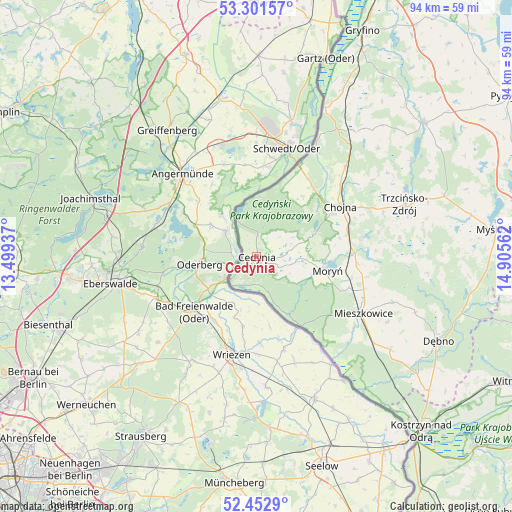
Cedynia GPS coordinates[2]
52° 52' 45.516" North, 14° 12' 8.964" East
| Map corner | latitude | longitude |
|---|---|---|
| Upper-left | 53.30157°, | 13.49937° |
| Center: | 52.87931°, | 14.20249° |
| Lower-right: | 52.4529°, | 14.90562° |
| Map W x H: | 94.4×94.4 km | = 58.7×58.7mi |
| max Lat: | 54.83135° ⇑18% North |
| Cedynia: | 52.87931° |
| min Lat: | ⇓82% South 49.21328° |
| min Long | Cedynia | max Long |
| 14.20249° | 14.20249° | 24.03723° |
| W 0%⇐ | ⇒100% E |
Elevation
Elevation of Cedynia is 4 m = 13 ft, and this is 187.4 m = 615 ft below average elevation for this country.
| Max E: |
974 m = 3196 ft | 99.1% |
| Avg. | 191.4 m = 628 ft | |
| Cedynia | 4 m = 13 ft | |
Min E: |
-3 m = -10 ft | 0.9% |
See also: Poland elevation on elevation.city.
Geographical zone
Cedynia is located in North temperate zone (between Tropic of Cancer and the Arctic Circle). Distance of this North polar circle is 1521.5 km =945.4 mi to North.| Distance of | km | miles | from Cedynia |
|---|---|---|---|
| North Pole | 4127.4 | 2564.6 | to North |
| Arctic Circle | 1521.5 | 945.4 | to North |
| Tropic Cancer | 3273.7 | 2034.2 | to South |
| Equator | 5879.6 | 3653.4 | to South |


Nearby cities:
15 places around Cedynia: (largest is in red/bold)
• Banie
39.4 km =24.5 mi,  51°
51°
• Bielin
17.8 km =11.1 mi,  108°
108°
• Boleszkowice
30 km =18.6 mi,  124°
124°
• Chojna
17.8 km =11.1 mi,  58°
58°
• Cychry
39.6 km =24.6 mi, 121°
• Dargomyśl
35.5 km =22.1 mi, 122°
• Dębno
36.8 km =22.9 mi, 115°
• Lubanowo
39.1 km =24.3 mi,  44°
44°
• Mieszkowice
22.1 km =13.7 mi, 117°
• Moryń
13 km =8.1 mi,  100°
100°
• Oborzany
34.8 km =21.6 mi, 116°
• Troszyn
26.9 km =16.7 mi, 116°
• Trzcińsko Zdrój
28.7 km =17.8 mi,  70°
70°
• Widuchowa
30.3 km =18.8 mi,  24°
24°
• Witnica
18.3 km =11.4 mi,  93°
93°
Sources, notices
• [Note1] Compared only with cities in Poland existing in our database
• [Src1] Map data: © OpenStreetMap contributors (CC-BY-SA)
• [Src2] Other city data from geonames.org with taken over terms of usage.
• [Src3] Geographical zone / Annual Mean Temperature by Robert A. Rohde @ Wikipedia
