Trzcińsko Zdrój geodata
Trzcińsko Zdrój (West Pomerania) is a populated place; located in Poland in Europe/Warsaw (GMT+2) time zone. With population of 2,466 people, there are 1262 cities with bigger population in this country. Compared to other cities in Poland, 83.1% of cities are located further ↓South; 99.5% of cities are located further →East and 93.6% of cities have higher elevation than Trzcińsko Zdrój. Note1
Administrative division(s):
- Level 1: West Pomerania
- Level 2: Powiat gryfiński
- Level 3: Trzcińsko-Zdrój


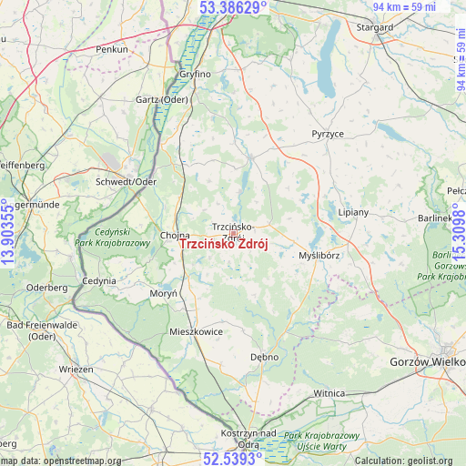
Trzcińsko Zdrój GPS coordinates[2]
52° 57' 53.532" North, 14° 36' 24.012" East
| Map corner | latitude | longitude |
|---|---|---|
| Upper-left | 53.38629°, | 13.90355° |
| Center: | 52.96487°, | 14.60667° |
| Lower-right: | 52.5393°, | 15.3098° |
| Map W x H: | 94.2×94.2 km | = 58.5×58.5mi |
| max Lat: | 54.83135° ⇑16.9% North |
| Trzcińsko Zdrój: | 52.96487° |
| min Lat: | ⇓83.1% South 49.21328° |
| min Long | Trzcińsko Zdr� | max Long |
| 14.20249° | 14.60667° | 24.03723° |
| W 0.5%⇐ | ⇒99.5% E |
Elevation
Elevation of Trzcińsko Zdrój is 56 m = 184 ft, and this is 135.4 m = 444 ft below average elevation for this country.
| Max E: |
974 m = 3196 ft | 93.6% |
| Avg. | 191.4 m = 628 ft | |
| Trzcińsko Zdrój | 56 m = 184 ft | |
Min E: |
-3 m = -10 ft | 6.4% |
See also: Poland elevation on elevation.city.
Geographical zone
Trzcińsko Zdrój is located in North temperate zone (between Tropic of Cancer and the Arctic Circle). Distance of this North polar circle is 1512 km =939.5 mi to North.| Distance of | km | miles | from Trzcińsko Zdrój |
|---|---|---|---|
| North Pole | 4117.9 | 2558.7 | to North |
| Arctic Circle | 1512 | 939.5 | to North |
| Tropic Cancer | 3283.2 | 2040.1 | to South |
| Equator | 5889.1 | 3659.3 | to South |


Nearby cities:
15 places around Trzcińsko Zdrój: (largest is in red/bold)
• Banie
15.5 km =9.6 mi,  13°
13°
• Bielin
18.3 km =11.4 mi,  214°
214°
• Boleszkowice
26.8 km =16.7 mi,  185°
185°
• Chojna
12 km =7.5 mi,  269°
269°
• Dębno
25.9 km =16.1 mi,  166°
166°
• Kozielice
21.4 km =13.3 mi,  42°
42°
• Lipiany
24.6 km =15.3 mi,  79°
79°
• Lubanowo
18.4 km =11.4 mi,  1°
1°
• Mieszkowice
21.2 km =13.2 mi,  201°
201°
• Moryń
18.6 km =11.6 mi,  230°
230°
• Myślibórz
18.1 km =11.2 mi,  104°
104°
• Oborzany
25.5 km =15.8 mi, 171°
• Troszyn
21.8 km =13.5 mi, 188°
• Widuchowa
23.1 km =14.4 mi,  321°
321°
• Witnica
13.7 km =8.5 mi,  220°
220°
Sources, notices
• [Note1] Compared only with cities in Poland existing in our database
• [Src1] Map data: © OpenStreetMap contributors (CC-BY-SA)
• [Src2] Other city data from geonames.org with taken over terms of usage.
• [Src3] Geographical zone / Annual Mean Temperature by Robert A. Rohde @ Wikipedia
