Mieszkowice geodata
Mieszkowice (West Pomerania) is a seat of a third-order administrative division; located in Poland in Europe/Warsaw (GMT+2) time zone. With population of 3,562 people, there are 898 cities with bigger population in this country. Compared to other cities in Poland, 80.8% of cities are located further ↓South; 99.6% of cities are located further →East and 94.7% of cities have higher elevation than Mieszkowice. Note1


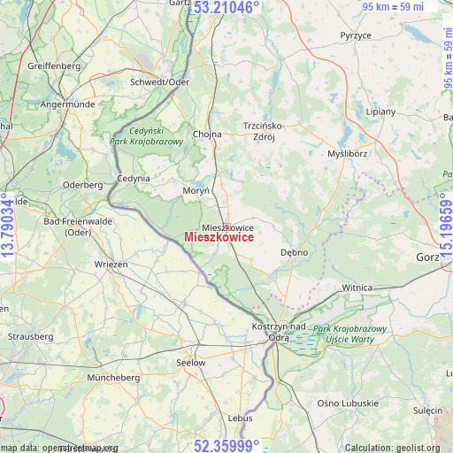
Mieszkowice GPS coordinates[2]
52° 47' 14.28" North, 14° 29' 36.456" East
| Map corner | latitude | longitude |
|---|---|---|
| Upper-left | 53.21046°, | 13.79034° |
| Center: | 52.7873°, | 14.49346° |
| Lower-right: | 52.35999°, | 15.19659° |
| Map W x H: | 94.6×94.6 km | = 58.8×58.8mi |
| max Lat: | 54.83135° ⇑19.2% North |
| Mieszkowice: | 52.7873° |
| min Lat: | ⇓80.8% South 49.21328° |
| min Long | Mieszkowice | max Long |
| 14.20249° | 14.49346° | 24.03723° |
| W 0.4%⇐ | ⇒99.6% E |
Elevation
Elevation of Mieszkowice is 46 m = 151 ft, and this is 145.4 m = 477 ft below average elevation for this country.
| Max E: |
974 m = 3196 ft | 94.7% |
| Avg. | 191.4 m = 628 ft | |
| Mieszkowice | 46 m = 151 ft | |
Min E: |
-3 m = -10 ft | 5.3% |
See also: Poland elevation on elevation.city.
Geographical zone
Mieszkowice is located in North temperate zone (between Tropic of Cancer and the Arctic Circle). Distance of this North polar circle is 1531.8 km =951.8 mi to North.| Distance of | km | miles | from Mieszkowice |
|---|---|---|---|
| North Pole | 4137.7 | 2571 | to North |
| Arctic Circle | 1531.8 | 951.8 | to North |
| Tropic Cancer | 3263.5 | 2027.8 | to South |
| Equator | 5869.4 | 3647.1 | to South |


Nearby cities:
15 places around Mieszkowice: (largest is in red/bold)
• Bielin
5.3 km =3.3 mi,  330°
330°
• Boleszkowice
8.6 km =5.3 mi,  143°
143°
• Cedynia
22.1 km =13.7 mi,  297°
297°
• Chojna
20.1 km =12.5 mi,  347°
347°
• Cychry
17.7 km =11 mi,  126°
126°
• Dargomyśl
13.7 km =8.5 mi, 131°
• Dębno
14.8 km =9.2 mi,  111°
111°
• Kostrzyn nad Odrą
24.6 km =15.3 mi,  154°
154°
• Moryń
10.3 km =6.4 mi,  319°
319°
• Myślibórz
29.4 km =18.3 mi,  58°
58°
• Oborzany
12.8 km =8 mi,  115°
115°
• Sarbinowo
18.9 km =11.7 mi, 139°
• Troszyn
4.8 km =3 mi, 112°
• Trzcińsko Zdrój
21.2 km =13.2 mi,  21°
21°
• Witnica
9.3 km =5.8 mi, 352°
Sources, notices
• [Note1] Compared only with cities in Poland existing in our database
• [Src1] Map data: © OpenStreetMap contributors (CC-BY-SA)
• [Src2] Other city data from geonames.org with taken over terms of usage.
• [Src3] Geographical zone / Annual Mean Temperature by Robert A. Rohde @ Wikipedia
