Radocza geodata
Radocza (Lesser Poland) is a populated place; located in Poland in Europe/Warsaw (GMT+2) time zone. With population of 1,997 people, there are 1503 cities with bigger population in this country. Compared to other cities in Poland, 86.7% of cities are located further ↑North; 51.4% of cities are located further →East and 79.8% of cities have lower elevation than Radocza. Note1


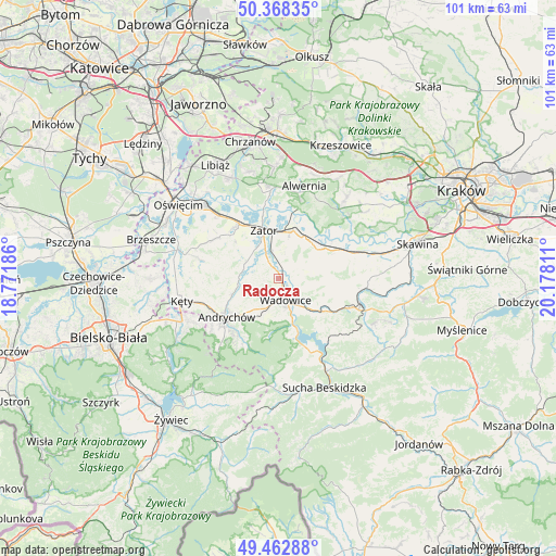
Radocza GPS coordinates[2]
49° 55' 3.864" North, 19° 28' 29.928" East
| Map corner | latitude | longitude |
|---|---|---|
| Upper-left | 50.36835°, | 18.77186° |
| Center: | 49.91774°, | 19.47498° |
| Lower-right: | 49.46288°, | 20.17811° |
| Map W x H: | 100.7×100.7 km | = 62.6×62.6mi |
| max Lat: | 54.83135° ⇑86.7% North |
| Radocza: | 49.91774° |
| min Lat: | ⇓13.3% South 49.21328° |
| min Long | Radocza | max Long |
| 14.20249° | 19.47498° | 24.03723° |
| W 48.6%⇐ | ⇒51.4% E |
Elevation
Elevation of Radocza is 265 m = 869 ft, and this is 73.6 m = 241 ft above average elevation for this country.
| Max E: |
974 m = 3196 ft | 20.2% |
| Radocza | 265 m 869 ft | |
| Avg. | 191.4 m = 628 ft | |
Min E: |
-3 m = -10 ft | 79.8% |
See also: Poland elevation on elevation.city.
Geographical zone
Radocza is located in North temperate zone (between Tropic of Cancer and the Arctic Circle). Distance of this North polar circle is 1850.8 km =1150 mi to North.| Distance of | km | miles | from Radocza |
|---|---|---|---|
| North Pole | 4456.7 | 2769.3 | to North |
| Arctic Circle | 1850.8 | 1150 | to North |
| Tropic Cancer | 2944.4 | 1829.6 | to South |
| Equator | 5550.3 | 3448.8 | to South |


Nearby cities:
15 places around Radocza: (largest is in red/bold)
• Bachowice
4.7 km =2.9 mi,  16°
16°
• Barwałd Dolny
9 km =5.6 mi,  129°
129°
• Chocznia
5.1 km =3.2 mi,  196°
196°
• Frydrychowice
4.2 km =2.6 mi,  250°
250°
• Gierałtowice
6.7 km =4.2 mi,  296°
296°
• Graboszyce
3.6 km =2.2 mi,  329°
329°
• Inwałd
8.4 km =5.2 mi,  224°
224°
• Jaroszowice
6.9 km =4.3 mi,  152°
152°
• Klecza Dolna
5.9 km =3.7 mi, 130°
• Klecza Górna
8.3 km =5.2 mi,  135°
135°
• Ryczów
8.9 km =5.5 mi,  37°
37°
• Tomice
2.3 km =1.4 mi,  164°
164°
• Wadowice
4 km =2.5 mi, 161°
• Witanowice
3.6 km =2.2 mi,  89°
89°
• Woźniki
2.5 km =1.6 mi,  26°
26°
Sources, notices
• [Note1] Compared only with cities in Poland existing in our database
• [Src1] Map data: © OpenStreetMap contributors (CC-BY-SA)
• [Src2] Other city data from geonames.org with taken over terms of usage.
• [Src3] Geographical zone / Annual Mean Temperature by Robert A. Rohde @ Wikipedia
