Wilków geodata
Wilków (Opole Voivodeship) is a seat of a third-order administrative division; located in Poland in Europe/Warsaw (GMT+2) time zone. With population of 900 people, there are 2674 cities with bigger population in this country. Compared to other cities in Poland, 52.5% of cities are located further ↑North; 78.7% of cities are located further →East and 55.3% of cities have higher elevation than Wilków. Note1


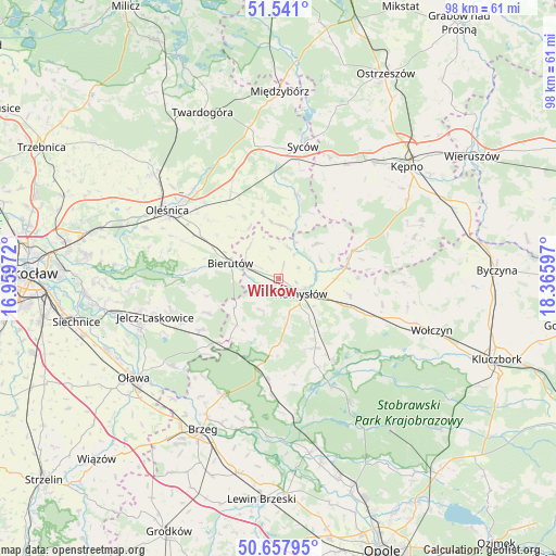
Wilków GPS coordinates[2]
51° 6' 5.688" North, 17° 39' 46.224" East
| Map corner | latitude | longitude |
|---|---|---|
| Upper-left | 51.541°, | 16.95972° |
| Center: | 51.10158°, | 17.66284° |
| Lower-right: | 50.65795°, | 18.36597° |
| Map W x H: | 98.2×98.2 km | = 61×61mi |
| max Lat: | 54.83135° ⇑52.5% North |
| Wilków: | 51.10158° |
| min Lat: | ⇓47.5% South 49.21328° |
| min Long | Wilków | max Long |
| 14.20249° | 17.66284° | 24.03723° |
| W 21.3%⇐ | ⇒78.7% E |
Elevation
Elevation of Wilków is 158 m = 518 ft, and this is 33.4 m = 110 ft below average elevation for this country.
| Max E: |
974 m = 3196 ft | 55.3% |
| Avg. | 191.4 m = 628 ft | |
| Wilków | 158 m = 518 ft | |
Min E: |
-3 m = -10 ft | 44.7% |
See also: Poland elevation on elevation.city.
Geographical zone
Wilków is located in North temperate zone (between Tropic of Cancer and the Arctic Circle). Distance of this North polar circle is 1719.2 km =1068.3 mi to North.| Distance of | km | miles | from Wilków |
|---|---|---|---|
| North Pole | 4325.1 | 2687.5 | to North |
| Arctic Circle | 1719.2 | 1068.3 | to North |
| Tropic Cancer | 3076 | 1911.3 | to South |
| Equator | 5682 | 3530.6 | to South |


Nearby cities:
15 places around Wilków: (largest is in red/bold)
• Bierutów
8.5 km =5.3 mi,  287°
287°
• Domaradz
22.1 km =13.7 mi,  140°
140°
• Domaszowice
17.1 km =10.6 mi,  112°
112°
• Dziadowa Kłoda
15.2 km =9.4 mi,  12°
12°
• Idzikowice
5.5 km =3.4 mi,  24°
24°
• Miechów
19 km =11.8 mi,  25°
25°
• Minkowice Oławskie
16.8 km =10.4 mi,  236°
236°
• Miłocice
14 km =8.7 mi, 243°
• Namysłów
5.1 km =3.2 mi,  124°
124°
• Perzów
22 km =13.7 mi, 27°
• Rychtal
14 km =8.7 mi,  69°
69°
• Solniki Wielkie
14.9 km =9.3 mi,  297°
297°
• Strzelce
14.4 km =8.9 mi, 106°
• Wielki Buczek
21.4 km =13.3 mi,  80°
80°
• Świerczów
17.1 km =10.6 mi,  156°
156°
Sources, notices
• [Note1] Compared only with cities in Poland existing in our database
• [Src1] Map data: © OpenStreetMap contributors (CC-BY-SA)
• [Src2] Other city data from geonames.org with taken over terms of usage.
• [Src3] Geographical zone / Annual Mean Temperature by Robert A. Rohde @ Wikipedia
