Namysłów geodata
Namysłów (Opole Voivodeship) is a seat of a second-order administrative division; located in Poland in Europe/Warsaw (GMT+2) time zone. With population of 16,376 people, there are 305 cities with bigger population in this country. Compared to other cities in Poland, 53.3% of cities are located further ↑North; 78% of cities are located further →East and 56% of cities have higher elevation than Namysłów. Note1
Administrative division(s):
- Level 1: Opole Voivodeship
- Level 2: Powiat namysłowski
- Level 3: Namysłów


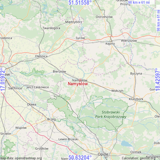
Namysłów GPS coordinates[2]
51° 4' 33.312" North, 17° 43' 22.224" East
| Map corner | latitude | longitude |
|---|---|---|
| Upper-left | 51.51558°, | 17.01972° |
| Center: | 51.07592°, | 17.72284° |
| Lower-right: | 50.63204°, | 18.42597° |
| Map W x H: | 98.2×98.2 km | = 61×61mi |
| max Lat: | 54.83135° ⇑53.3% North |
| Namysłów: | 51.07592° |
| min Lat: | ⇓46.7% South 49.21328° |
| min Long | Namysłów | max Long |
| 14.20249° | 17.72284° | 24.03723° |
| W 22%⇐ | ⇒78% E |
Elevation
Elevation of Namysłów is 156 m = 512 ft, and this is 35.4 m = 116 ft below average elevation for this country.
| Max E: |
974 m = 3196 ft | 56% |
| Avg. | 191.4 m = 628 ft | |
| Namysłów | 156 m = 512 ft | |
Min E: |
-3 m = -10 ft | 44% |
See also: Poland elevation on elevation.city.
Geographical zone
Namysłów is located in North temperate zone (between Tropic of Cancer and the Arctic Circle). Distance of this North polar circle is 1722.1 km =1070.1 mi to North.| Distance of | km | miles | from Namysłów |
|---|---|---|---|
| North Pole | 4328 | 2689.3 | to North |
| Arctic Circle | 1722.1 | 1070.1 | to North |
| Tropic Cancer | 3073.2 | 1909.6 | to South |
| Equator | 5679.1 | 3528.8 | to South |


Nearby cities:
15 places around Namysłów: (largest is in red/bold)
• Bierutów
13.5 km =8.4 mi,  293°
293°
• Domaradz
17.3 km =10.7 mi,  144°
144°
• Domaszowice
12.2 km =7.6 mi,  107°
107°
• Dziadowa Kłoda
17.8 km =11.1 mi,  356°
356°
• Idzikowice
8.1 km =5 mi,  345°
345°
• Miechów
20.5 km =12.7 mi,  10°
10°
• Minkowice Oławskie
19.3 km =12 mi,  250°
250°
• Miłocice
17.1 km =10.6 mi,  258°
258°
• Pokój
20.9 km =13 mi,  157°
157°
• Rychtal
11.8 km =7.3 mi,  49°
49°
• Solniki Wielkie
20 km =12.4 mi,  299°
299°
• Strzelce
9.7 km =6 mi,  96°
96°
• Wielki Buczek
18.1 km =11.2 mi,  69°
69°
• Wilków
5.1 km =3.2 mi, 304°
• Świerczów
13.1 km =8.1 mi,  168°
168°
Sources, notices
• [Note1] Compared only with cities in Poland existing in our database
• [Src1] Map data: © OpenStreetMap contributors (CC-BY-SA)
• [Src2] Other city data from geonames.org with taken over terms of usage.
• [Src3] Geographical zone / Annual Mean Temperature by Robert A. Rohde @ Wikipedia
