Domaradz geodata
Domaradz (Opole Voivodeship) is a populated place; located in Poland in Europe/Warsaw (GMT+2) time zone. With population of 989 people, there are 2521 cities with bigger population in this country. Compared to other cities in Poland, 56.5% of cities are located further ↑North; 76.5% of cities are located further →East and 56.4% of cities have higher elevation than Domaradz. Note1


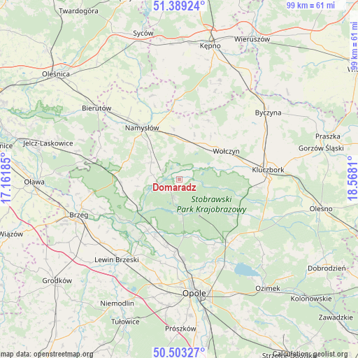
Domaradz GPS coordinates[2]
50° 56' 54.132" North, 17° 51' 53.892" East
| Map corner | latitude | longitude |
|---|---|---|
| Upper-left | 51.38924°, | 17.16185° |
| Center: | 50.94837°, | 17.86497° |
| Lower-right: | 50.50327°, | 18.5681° |
| Map W x H: | 98.5×98.5 km | = 61.2×61.2mi |
| max Lat: | 54.83135° ⇑56.5% North |
| Domaradz: | 50.94837° |
| min Lat: | ⇓43.5% South 49.21328° |
| min Long | Domaradz | max Long |
| 14.20249° | 17.86497° | 24.03723° |
| W 23.5%⇐ | ⇒76.5% E |
Elevation
Elevation of Domaradz is 155 m = 509 ft, and this is 36.4 m = 119 ft below average elevation for this country.
| Max E: |
974 m = 3196 ft | 56.4% |
| Avg. | 191.4 m = 628 ft | |
| Domaradz | 155 m = 509 ft | |
Min E: |
-3 m = -10 ft | 43.6% |
See also: Poland elevation on elevation.city.
Geographical zone
Domaradz is located in North temperate zone (between Tropic of Cancer and the Arctic Circle). Distance of this North polar circle is 1736.2 km =1078.8 mi to North.| Distance of | km | miles | from Domaradz |
|---|---|---|---|
| North Pole | 4342.1 | 2698.1 | to North |
| Arctic Circle | 1736.2 | 1078.8 | to North |
| Tropic Cancer | 3059 | 1900.8 | to South |
| Equator | 5664.9 | 3520 | to South |


Nearby cities:
15 places around Domaradz: (largest is in red/bold)
• Borkowice
20.5 km =12.7 mi,  92°
92°
• Chróścice
19 km =11.8 mi,  191°
191°
• Dobrzeń Wielki
20 km =12.4 mi,  183°
183°
• Domaszowice
10.6 km =6.6 mi,  8°
8°
• Kup
15.8 km =9.8 mi, 175°
• Murów
11 km =6.8 mi,  149°
149°
• Namysłów
17.3 km =10.7 mi,  324°
324°
• Pokój
5.4 km =3.4 mi,  200°
200°
• Popielów
16 km =9.9 mi,  212°
212°
• Strzelce
13.1 km =8.1 mi,  358°
358°
• Swierkle
21 km =13 mi,  167°
167°
• Wielki Buczek
21.8 km =13.5 mi,  18°
18°
• Wołczyn
15.1 km =9.4 mi,  58°
58°
• Łubniany
20.4 km =12.7 mi, 152°
• Świerczów
7.6 km =4.7 mi,  279°
279°
Sources, notices
• [Note1] Compared only with cities in Poland existing in our database
• [Src1] Map data: © OpenStreetMap contributors (CC-BY-SA)
• [Src2] Other city data from geonames.org with taken over terms of usage.
• [Src3] Geographical zone / Annual Mean Temperature by Robert A. Rohde @ Wikipedia
