Dziadowa Kłoda geodata
Dziadowa Kłoda (Lower Silesia) is a populated place; located in Poland in Europe/Warsaw (GMT+2) time zone. With population of 1,174 people, there are 2235 cities with bigger population in this country. Compared to other cities in Poland, 51.7% of cities are located further ↓South; 78.2% of cities are located further →East and 51.6% of cities have higher elevation than Dziadowa Kłoda. Note1
Administrative division(s):
- Level 1: Lower Silesia
- Level 2: Powiat oleśnicki
- Level 3: Dziadowa Kłoda


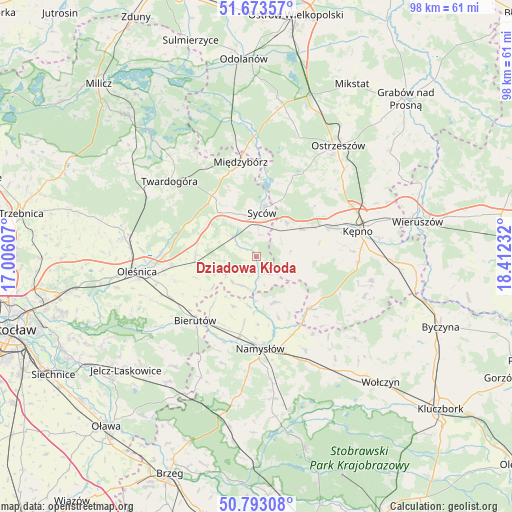
Dziadowa Kłoda GPS coordinates[2]
51° 14' 7.548" North, 17° 42' 33.084" East
| Map corner | latitude | longitude |
|---|---|---|
| Upper-left | 51.67357°, | 17.00607° |
| Center: | 51.23543°, | 17.70919° |
| Lower-right: | 50.79308°, | 18.41232° |
| Map W x H: | 97.9×97.9 km | = 60.8×60.8mi |
| max Lat: | 54.83135° ⇑48.3% North |
| Dziadowa Kłoda: | 51.23543° |
| min Lat: | ⇓51.7% South 49.21328° |
| min Long | Dziadowa Kłoda | max Long |
| 14.20249° | 17.70919° | 24.03723° |
| W 21.8%⇐ | ⇒78.2% E |
Elevation
Elevation of Dziadowa Kłoda is 168 m = 551 ft, and this is 23.4 m = 77 ft below average elevation for this country.
| Max E: |
974 m = 3196 ft | 51.6% |
| Avg. | 191.4 m = 628 ft | |
| Dziadowa Kłoda | 168 m = 551 ft | |
Min E: |
-3 m = -10 ft | 48.4% |
See also: Poland elevation on elevation.city.
Geographical zone
Dziadowa Kłoda is located in North temperate zone (between Tropic of Cancer and the Arctic Circle). Distance of this North polar circle is 1704.3 km =1059 mi to North.| Distance of | km | miles | from Dziadowa Kłoda |
|---|---|---|---|
| North Pole | 4310.2 | 2678.2 | to North |
| Arctic Circle | 1704.3 | 1059 | to North |
| Tropic Cancer | 3090.9 | 1920.6 | to South |
| Equator | 5696.8 | 3539.8 | to South |


Nearby cities:
15 places around Dziadowa Kłoda: (largest is in red/bold)
• Baranów
20.8 km =12.9 mi,  81°
81°
• Bierutów
16.8 km =10.4 mi,  222°
222°
• Bralin
14.6 km =9.1 mi,  67°
67°
• Idzikowice
10 km =6.2 mi,  185°
185°
• Kobyla Góra
18.3 km =11.4 mi,  29°
29°
• Kępno
20.1 km =12.5 mi, 76°
• Miechów
5.4 km =3.4 mi,  64°
64°
• Międzybórz
18.1 km =11.2 mi,  350°
350°
• Namysłów
17.8 km =11.1 mi,  176°
176°
• Perzów
8.3 km =5.2 mi, 57°
• Rychtal
14.1 km =8.8 mi,  135°
135°
• Solniki Wielkie
18.3 km =11.4 mi,  244°
244°
• Syców
8.1 km =5 mi,  5°
5°
• Wielki Buczek
21.1 km =13.1 mi,  122°
122°
• Wilków
15.2 km =9.4 mi, 192°
Sources, notices
• [Note1] Compared only with cities in Poland existing in our database
• [Src1] Map data: © OpenStreetMap contributors (CC-BY-SA)
• [Src2] Other city data from geonames.org with taken over terms of usage.
• [Src3] Geographical zone / Annual Mean Temperature by Robert A. Rohde @ Wikipedia
