Strzelce geodata
Strzelce (Opole Voivodeship) is a populated place; located in Poland in Europe/Warsaw (GMT+2) time zone. With population of 870 people, there are 2725 cities with bigger population in this country. Compared to other cities in Poland, 53.7% of cities are located further ↑North; 76.6% of cities are located further →East and 52.9% of cities have higher elevation than Strzelce. Note1
Administrative division(s):
- Level 1: Opole Voivodeship
- Level 2: Powiat namysłowski
- Level 3: Domaszowice


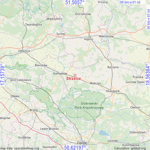
Strzelce GPS coordinates[2]
51° 3' 57.384" North, 17° 51' 37.836" East
| Map corner | latitude | longitude |
|---|---|---|
| Upper-left | 51.5057°, | 17.15739° |
| Center: | 51.06594°, | 17.86051° |
| Lower-right: | 50.62197°, | 18.56364° |
| Map W x H: | 98.3×98.3 km | = 61.1×61.1mi |
| max Lat: | 54.83135° ⇑53.7% North |
| Strzelce: | 51.06594° |
| min Lat: | ⇓46.3% South 49.21328° |
| min Long | Strzelce | max Long |
| 14.20249° | 17.86051° | 24.03723° |
| W 23.4%⇐ | ⇒76.6% E |
Elevation
Elevation of Strzelce is 164 m = 538 ft, and this is 27.4 m = 90 ft below average elevation for this country.
| Max E: |
974 m = 3196 ft | 52.9% |
| Avg. | 191.4 m = 628 ft | |
| Strzelce | 164 m = 538 ft | |
Min E: |
-3 m = -10 ft | 47.1% |
See also: Poland elevation on elevation.city.
Geographical zone
Strzelce is located in North temperate zone (between Tropic of Cancer and the Arctic Circle). Distance of this North polar circle is 1723.2 km =1070.7 mi to North.| Distance of | km | miles | from Strzelce |
|---|---|---|---|
| North Pole | 4329.1 | 2690 | to North |
| Arctic Circle | 1723.2 | 1070.7 | to North |
| Tropic Cancer | 3072.1 | 1908.9 | to South |
| Equator | 5678 | 3528.1 | to South |


Nearby cities:
15 places around Strzelce: (largest is in red/bold)
• Bierutów
22.9 km =14.2 mi,  286°
286°
• Domaradz
13.1 km =8.1 mi,  178°
178°
• Domaszowice
3.2 km =2 mi,  142°
142°
• Dziadowa Kłoda
21.6 km =13.4 mi,  330°
330°
• Idzikowice
14.6 km =9.1 mi,  307°
307°
• Miechów
22 km =13.7 mi,  344°
344°
• Namysłów
9.7 km =6 mi,  276°
276°
• Pokój
18.2 km =11.3 mi,  185°
185°
• Rychtal
8.9 km =5.5 mi,  355°
355°
• Słupia pod Kępnem
23.1 km =14.4 mi,  33°
33°
• Trzcinica
15.1 km =9.4 mi,  41°
41°
• Wielki Buczek
10.5 km =6.5 mi, 44°
• Wilków
14.4 km =8.9 mi, 286°
• Wołczyn
14.3 km =8.9 mi,  111°
111°
• Świerczów
13.7 km =8.5 mi,  211°
211°
Sources, notices
• [Note1] Compared only with cities in Poland existing in our database
• [Src1] Map data: © OpenStreetMap contributors (CC-BY-SA)
• [Src2] Other city data from geonames.org with taken over terms of usage.
• [Src3] Geographical zone / Annual Mean Temperature by Robert A. Rohde @ Wikipedia
