Brzuze geodata
Brzuze (Kujawsko-Pomorskie) is a seat of a third-order administrative division; located in Poland in Europe/Warsaw (GMT+2) time zone. With population of 449 people, there are 3567 cities with bigger population in this country. Compared to other cities in Poland, 84.3% of cities are located further ↓South; 55% of cities are located further →East and 69.3% of cities have higher elevation than Brzuze. Note1


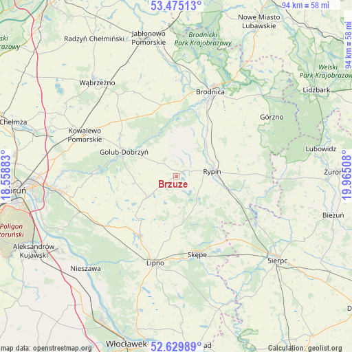
Brzuze GPS coordinates[2]
53° 3' 16.488" North, 19° 15' 43.02" East
| Map corner | latitude | longitude |
|---|---|---|
| Upper-left | 53.47513°, | 18.55883° |
| Center: | 53.05458°, | 19.26195° |
| Lower-right: | 52.62989°, | 19.96508° |
| Map W x H: | 94×94 km | = 58.4×58.4mi |
| max Lat: | 54.83135° ⇑15.7% North |
| Brzuze: | 53.05458° |
| min Lat: | ⇓84.3% South 49.21328° |
| min Long | Brzuze | max Long |
| 14.20249° | 19.26195° | 24.03723° |
| W 45%⇐ | ⇒55% E |
Elevation
Elevation of Brzuze is 122 m = 400 ft, and this is 69.4 m = 228 ft below average elevation for this country.
| Max E: |
974 m = 3196 ft | 69.3% |
| Avg. | 191.4 m = 628 ft | |
| Brzuze | 122 m = 400 ft | |
Min E: |
-3 m = -10 ft | 30.7% |
See also: Poland elevation on elevation.city.
Geographical zone
Brzuze is located in North temperate zone (between Tropic of Cancer and the Arctic Circle). Distance of this North polar circle is 1502.1 km =933.4 mi to North.| Distance of | km | miles | from Brzuze |
|---|---|---|---|
| North Pole | 4107.9 | 2552.5 | to North |
| Arctic Circle | 1502.1 | 933.4 | to North |
| Tropic Cancer | 3293.2 | 2046.3 | to South |
| Equator | 5899.1 | 3665.5 | to South |


Nearby cities:
15 places around Brzuze: (largest is in red/bold)
• Chrostkowo
12.3 km =7.6 mi,  182°
182°
• Golub-Dobrzyń
15.2 km =9.4 mi,  294°
294°
• Kikół
18.7 km =11.6 mi,  210°
210°
• Lisewo
16.6 km =10.3 mi,  309°
309°
• Lubin
16.7 km =10.4 mi,  218°
218°
• Osiek
15.2 km =9.4 mi,  33°
33°
• Ostrowite
2.7 km =1.7 mi,  52°
52°
• Ostrowite
21 km =13 mi,  297°
297°
• Radomin
5.8 km =3.6 mi, 308°
• Rogowo
11.9 km =7.4 mi,  136°
136°
• Rypin
9.9 km =6.2 mi,  82°
82°
• Skępe
21.7 km =13.5 mi,  163°
163°
• Wielgie
12.2 km =7.6 mi,  241°
241°
• Wąpielsk
9.3 km =5.8 mi,  6°
6°
• Zbójno
8.7 km =5.4 mi,  233°
233°
Sources, notices
• [Note1] Compared only with cities in Poland existing in our database
• [Src1] Map data: © OpenStreetMap contributors (CC-BY-SA)
• [Src2] Other city data from geonames.org with taken over terms of usage.
• [Src3] Geographical zone / Annual Mean Temperature by Robert A. Rohde @ Wikipedia
