Ostrowite geodata
Ostrowite (Kujawsko-Pomorskie) is a populated place; located in Poland in Europe/Warsaw (GMT+2) time zone. With population of 698 people, there are 3079 cities with bigger population in this country. Compared to other cities in Poland, 85.5% of cities are located further ↓South; 60.3% of cities are located further →East and 84.6% of cities have higher elevation than Ostrowite. Note1
Administrative division(s):
- Level 1: Kujawsko-Pomorskie
- Level 2: Powiat golubsko-dobrzyński
- Level 3: Golub-Dobrzyń


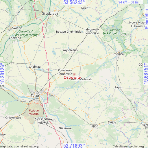
Ostrowite GPS coordinates[2]
53° 8' 33.9" North, 18° 59' 3.768" East
| Map corner | latitude | longitude |
|---|---|---|
| Upper-left | 53.56243°, | 18.28126° |
| Center: | 53.14275°, | 18.98438° |
| Lower-right: | 52.71893°, | 19.68751° |
| Map W x H: | 93.8×93.8 km | = 58.3×58.3mi |
| max Lat: | 54.83135° ⇑14.5% North |
| Ostrowite: | 53.14275° |
| min Lat: | ⇓85.5% South 49.21328° |
| min Long | Ostrowite | max Long |
| 14.20249° | 18.98438° | 24.03723° |
| W 39.7%⇐ | ⇒60.3% E |
Elevation
Elevation of Ostrowite is 90 m = 295 ft, and this is 101.4 m = 333 ft below average elevation for this country.
| Max E: |
974 m = 3196 ft | 84.6% |
| Avg. | 191.4 m = 628 ft | |
| Ostrowite | 90 m = 295 ft | |
Min E: |
-3 m = -10 ft | 15.4% |
See also: Poland elevation on elevation.city.
Geographical zone
Ostrowite is located in North temperate zone (between Tropic of Cancer and the Arctic Circle). Distance of this North polar circle is 1492.3 km =927.3 mi to North.| Distance of | km | miles | from Ostrowite |
|---|---|---|---|
| North Pole | 4098.1 | 2546.4 | to North |
| Arctic Circle | 1492.3 | 927.3 | to North |
| Tropic Cancer | 3303 | 2052.4 | to South |
| Equator | 5908.9 | 3671.6 | to South |


Nearby cities:
15 places around Ostrowite: (largest is in red/bold)
• Brzuze
21 km =13 mi,  117°
117°
• Ciechocin
10.4 km =6.5 mi,  201°
201°
• Dębowa Łąka
14.6 km =9.1 mi,  30°
30°
• Golub-Dobrzyń
5.8 km =3.6 mi,  127°
127°
• Kowalewo Pomorskie
5.9 km =3.7 mi,  282°
282°
• Książki
21.6 km =13.4 mi,  15°
15°
• Lisewo
5.7 km =3.5 mi,  82°
82°
• Lubicz Dolny
20.2 km =12.6 mi,  232°
232°
• Lubicz Górny
19.2 km =11.9 mi, 227°
• Obrowo
20.3 km =12.6 mi, 200°
• Radomin
15.3 km =9.5 mi,  113°
113°
• Wielgie
17.4 km =10.8 mi,  153°
153°
• Wąbrzeźno
15.4 km =9.6 mi,  350°
350°
• Wąpielsk
19.6 km =12.2 mi,  91°
91°
• Zbójno
18.9 km =11.7 mi,  142°
142°
Sources, notices
• [Note1] Compared only with cities in Poland existing in our database
• [Src1] Map data: © OpenStreetMap contributors (CC-BY-SA)
• [Src2] Other city data from geonames.org with taken over terms of usage.
• [Src3] Geographical zone / Annual Mean Temperature by Robert A. Rohde @ Wikipedia
