Fordon geodata
Fordon (Kujawsko-Pomorskie) is a populated place; located in Poland in Europe/Warsaw (GMT+2) time zone. With population of 70,000 people, there are 69 cities with bigger population in this country. Compared to other cities in Poland, 85.6% of cities are located further ↓South; 73.1% of cities are located further →East and 95.2% of cities have higher elevation than Fordon. Note1


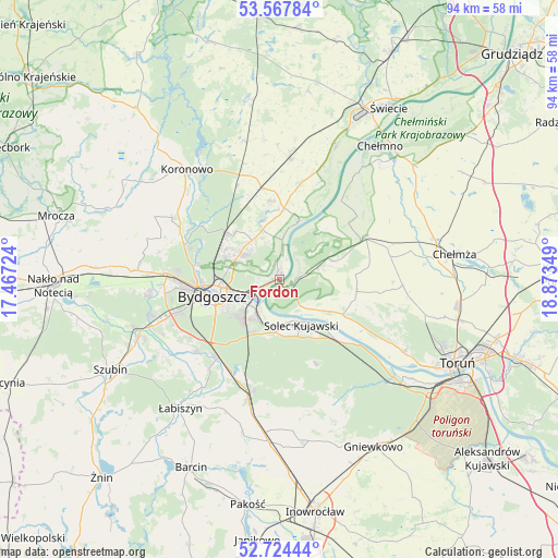
Fordon GPS coordinates[2]
53° 8' 53.556" North, 18° 10' 13.296" East
| Map corner | latitude | longitude |
|---|---|---|
| Upper-left | 53.56784°, | 17.46724° |
| Center: | 53.14821°, | 18.17036° |
| Lower-right: | 52.72444°, | 18.87349° |
| Map W x H: | 93.8×93.8 km | = 58.3×58.3mi |
| max Lat: | 54.83135° ⇑14.4% North |
| Fordon: | 53.14821° |
| min Lat: | ⇓85.6% South 49.21328° |
| min Long | Fordon | max Long |
| 14.20249° | 18.17036° | 24.03723° |
| W 26.9%⇐ | ⇒73.1% E |
Elevation
Elevation of Fordon is 39 m = 128 ft, and this is 152.4 m = 500 ft below average elevation for this country.
| Max E: |
974 m = 3196 ft | 95.2% |
| Avg. | 191.4 m = 628 ft | |
| Fordon | 39 m = 128 ft | |
Min E: |
-3 m = -10 ft | 4.8% |
See also: Fordon elevation on elevation.city.
Geographical zone
Fordon is located in North temperate zone (between Tropic of Cancer and the Arctic Circle). Distance of this North polar circle is 1491.6 km =926.8 mi to North.| Distance of | km | miles | from Fordon |
|---|---|---|---|
| North Pole | 4097.5 | 2546.1 | to North |
| Arctic Circle | 1491.6 | 926.8 | to North |
| Tropic Cancer | 3303.6 | 2052.8 | to South |
| Equator | 5909.5 | 3672 | to South |


Nearby cities:
15 places around Fordon: (largest is in red/bold)
• Białe Błota
18 km =11.2 mi,  250°
250°
• Bydgoszcz
11.2 km =7 mi,  255°
255°
• Dobrcz
13.1 km =8.1 mi,  353°
353°
• Dąbrowa Chełmińska
9.5 km =5.9 mi,  71°
71°
• Koronowo
24.1 km =15 mi,  319°
319°
• Nowa Wieś Wielka
20.4 km =12.7 mi,  195°
195°
• Osielsko
7.1 km =4.4 mi,  305°
305°
• Pruszcz
20.3 km =12.6 mi,  5°
5°
• Sicienko
25.4 km =15.8 mi,  284°
284°
• Solec Kujawski
8.1 km =5 mi,  152°
152°
• Toporzysko
9.8 km =6.1 mi,  123°
123°
• Unisław
16.1 km =10 mi,  63°
63°
• Zławieś Wielka
12.1 km =7.5 mi, 118°
• Łabiszyn
27.5 km =17.1 mi,  217°
217°
• Łubianka
20.8 km =12.9 mi,  92°
92°
Sources, notices
• [Note1] Compared only with cities in Poland existing in our database
• [Src1] Map data: © OpenStreetMap contributors (CC-BY-SA)
• [Src2] Other city data from geonames.org with taken over terms of usage.
• [Src3] Geographical zone / Annual Mean Temperature by Robert A. Rohde @ Wikipedia
