Bojanów geodata
Bojanów (Silesia) is a populated place; located in Poland in Europe/Warsaw (GMT+2) time zone. With population of 832 people, there are 2793 cities with bigger population in this country. Compared to other cities in Poland, 80.9% of cities are located further ↑North; 73.2% of cities are located further →East and 62.4% of cities have lower elevation than Bojanów. Note1


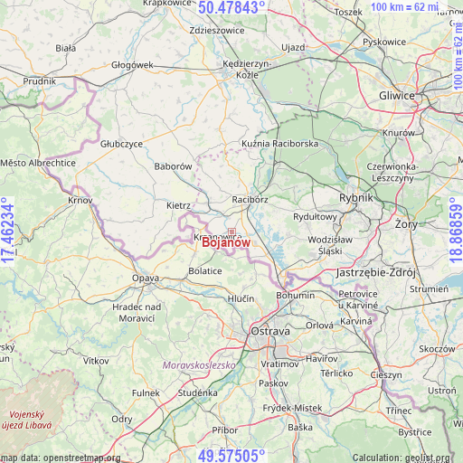
Bojanów GPS coordinates[2]
50° 1' 43.896" North, 18° 9' 55.656" East
| Map corner | latitude | longitude |
|---|---|---|
| Upper-left | 50.47843°, | 17.46234° |
| Center: | 50.02886°, | 18.16546° |
| Lower-right: | 49.57505°, | 18.86859° |
| Map W x H: | 100.4×100.4 km | = 62.4×62.4mi |
| max Lat: | 54.83135° ⇑80.9% North |
| Bojanów: | 50.02886° |
| min Lat: | ⇓19.1% South 49.21328° |
| min Long | Bojanów | max Long |
| 14.20249° | 18.16546° | 24.03723° |
| W 26.8%⇐ | ⇒73.2% E |
Elevation
Elevation of Bojanów is 207 m = 679 ft, and this is 15.6 m = 51 ft above average elevation for this country.
| Max E: |
974 m = 3196 ft | 37.6% |
| Bojanów | 207 m 679 ft | |
| Avg. | 191.4 m = 628 ft | |
Min E: |
-3 m = -10 ft | 62.4% |
See also: Poland elevation on elevation.city.
Geographical zone
Bojanów is located in North temperate zone (between Tropic of Cancer and the Arctic Circle). Distance of this North polar circle is 1838.5 km =1142.4 mi to North.| Distance of | km | miles | from Bojanów |
|---|---|---|---|
| North Pole | 4444.4 | 2761.6 | to North |
| Arctic Circle | 1838.5 | 1142.4 | to North |
| Tropic Cancer | 2956.8 | 1837.3 | to South |
| Equator | 5562.7 | 3456.5 | to South |


Nearby cities:
15 places around Bojanów: (largest is in red/bold)
• Borucin
2.4 km =1.5 mi,  193°
193°
• Kobyła
12.2 km =7.6 mi,  54°
54°
• Kornowac
12.6 km =7.8 mi,  67°
67°
• Krzanowice
3.3 km =2.1 mi,  248°
248°
• Krzyżanowice
9 km =5.6 mi,  125°
125°
• Lubomia
10.3 km =6.4 mi,  83°
83°
• Maków
10.7 km =6.6 mi,  326°
326°
• Nieboczowy
6.9 km =4.3 mi, 76°
• Pawłów
9.5 km =5.9 mi,  344°
344°
• Pietrowice Wielkie
8.1 km =5 mi,  319°
319°
• Pogrzebień
10.4 km =6.5 mi, 65°
• Racibórz
8 km =5 mi,  28°
28°
• Rudnik
11 km =6.8 mi,  7°
7°
• Syrynia
12.9 km =8 mi,  94°
94°
• Tworków
5.6 km =3.5 mi,  117°
117°
Sources, notices
• [Note1] Compared only with cities in Poland existing in our database
• [Src1] Map data: © OpenStreetMap contributors (CC-BY-SA)
• [Src2] Other city data from geonames.org with taken over terms of usage.
• [Src3] Geographical zone / Annual Mean Temperature by Robert A. Rohde @ Wikipedia
