Borucin geodata
Borucin (Silesia) is a populated place; located in Poland in Europe/Warsaw (GMT+2) time zone. With population of 1,247 people, there are 2130 cities with bigger population in this country. Compared to other cities in Poland, 82.1% of cities are located further ↑North; 73.4% of cities are located further →East and 66.4% of cities have lower elevation than Borucin. Note1


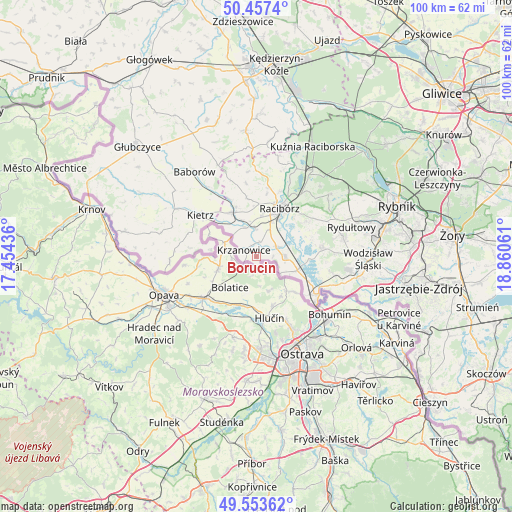
Borucin GPS coordinates[2]
50° 0' 27.468" North, 18° 9' 26.928" East
| Map corner | latitude | longitude |
|---|---|---|
| Upper-left | 50.4574°, | 17.45436° |
| Center: | 50.00763°, | 18.15748° |
| Lower-right: | 49.55362°, | 18.86061° |
| Map W x H: | 100.5×100.5 km | = 62.4×62.4mi |
| max Lat: | 54.83135° ⇑82.1% North |
| Borucin: | 50.00763° |
| min Lat: | ⇓17.9% South 49.21328° |
| min Long | Borucin | max Long |
| 14.20249° | 18.15748° | 24.03723° |
| W 26.6%⇐ | ⇒73.4% E |
Elevation
Elevation of Borucin is 218 m = 715 ft, and this is 26.6 m = 87 ft above average elevation for this country.
| Max E: |
974 m = 3196 ft | 33.6% |
| Borucin | 218 m 715 ft | |
| Avg. | 191.4 m = 628 ft | |
Min E: |
-3 m = -10 ft | 66.4% |
See also: Poland elevation on elevation.city.
Geographical zone
Borucin is located in North temperate zone (between Tropic of Cancer and the Arctic Circle). Distance of this North polar circle is 1840.8 km =1143.8 mi to North.| Distance of | km | miles | from Borucin |
|---|---|---|---|
| North Pole | 4446.7 | 2763.1 | to North |
| Arctic Circle | 1840.8 | 1143.8 | to North |
| Tropic Cancer | 2954.4 | 1835.8 | to South |
| Equator | 5560.3 | 3455 | to South |


Nearby cities:
15 places around Borucin: (largest is in red/bold)
• Bojanów
2.4 km =1.5 mi,  13°
13°
• Kietrz
13.6 km =8.5 mi,  306°
306°
• Krzanowice
2.8 km =1.7 mi,  295°
295°
• Krzyżanowice
8.4 km =5.2 mi,  109°
109°
• Lubomia
11.3 km =7 mi,  71°
71°
• Maków
12.5 km =7.8 mi,  334°
334°
• Nieboczowy
8.3 km =5.2 mi,  61°
61°
• Pawłów
11.7 km =7.3 mi,  349°
349°
• Pietrowice Wielkie
9.8 km =6.1 mi, 331°
• Pogrzebień
12.1 km =7.5 mi, 56°
• Racibórz
10.4 km =6.5 mi,  25°
25°
• Rogów
13.9 km =8.6 mi,  97°
97°
• Rudnik
13.5 km =8.4 mi, 8°
• Syrynia
13.5 km =8.4 mi,  84°
84°
• Tworków
5.6 km =3.5 mi,  92°
92°
Sources, notices
• [Note1] Compared only with cities in Poland existing in our database
• [Src1] Map data: © OpenStreetMap contributors (CC-BY-SA)
• [Src2] Other city data from geonames.org with taken over terms of usage.
• [Src3] Geographical zone / Annual Mean Temperature by Robert A. Rohde @ Wikipedia
