Murów geodata
Murów (Opole Voivodeship) is a populated place; located in Poland in Europe/Warsaw (GMT+2) time zone. With population of 1,577 people, there are 1790 cities with bigger population in this country. Compared to other cities in Poland, 58.8% of cities are located further ↑North; 75.8% of cities are located further →East and 54.2% of cities have higher elevation than Murów. Note1


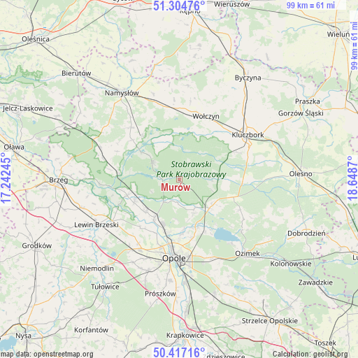
Murów GPS coordinates[2]
50° 51' 47.052" North, 17° 56' 44.052" East
| Map corner | latitude | longitude |
|---|---|---|
| Upper-left | 51.30476°, | 17.24245° |
| Center: | 50.86307°, | 17.94557° |
| Lower-right: | 50.41716°, | 18.6487° |
| Map W x H: | 98.7×98.7 km | = 61.3×61.3mi |
| max Lat: | 54.83135° ⇑58.8% North |
| Murów: | 50.86307° |
| min Lat: | ⇓41.2% South 49.21328° |
| min Long | Murów | max Long |
| 14.20249° | 17.94557° | 24.03723° |
| W 24.2%⇐ | ⇒75.8% E |
Elevation
Elevation of Murów is 161 m = 528 ft, and this is 30.4 m = 100 ft below average elevation for this country.
| Max E: |
974 m = 3196 ft | 54.2% |
| Avg. | 191.4 m = 628 ft | |
| Murów | 161 m = 528 ft | |
Min E: |
-3 m = -10 ft | 45.8% |
See also: Poland elevation on elevation.city.
Geographical zone
Murów is located in North temperate zone (between Tropic of Cancer and the Arctic Circle). Distance of this North polar circle is 1745.7 km =1084.7 mi to North.| Distance of | km | miles | from Murów |
|---|---|---|---|
| North Pole | 4351.6 | 2704 | to North |
| Arctic Circle | 1745.7 | 1084.7 | to North |
| Tropic Cancer | 3049.5 | 1894.9 | to South |
| Equator | 5655.4 | 3514.1 | to South |


Nearby cities:
15 places around Murów: (largest is in red/bold)
• Bierdzany
15.7 km =9.8 mi,  108°
108°
• Borkowice
17.2 km =10.7 mi,  59°
59°
• Chróścice
13.1 km =8.1 mi,  225°
225°
• Czarnowąsy
15.3 km =9.5 mi,  192°
192°
• Dobrzeń Wielki
12.6 km =7.8 mi,  213°
213°
• Domaradz
11 km =6.8 mi,  329°
329°
• Kup
7.6 km =4.7 mi, 214°
• Pokój
8.8 km =5.5 mi,  300°
300°
• Popielów
14.7 km =9.1 mi,  253°
253°
• Swierkle
11 km =6.8 mi, 185°
• Turawa
16.5 km =10.3 mi,  145°
145°
• Wołczyn
18.8 km =11.7 mi,  22°
22°
• Węgry
14.3 km =8.9 mi,  159°
159°
• Łubniany
9.4 km =5.8 mi, 155°
• Świerczów
17 km =10.6 mi,  309°
309°
Sources, notices
• [Note1] Compared only with cities in Poland existing in our database
• [Src1] Map data: © OpenStreetMap contributors (CC-BY-SA)
• [Src2] Other city data from geonames.org with taken over terms of usage.
• [Src3] Geographical zone / Annual Mean Temperature by Robert A. Rohde @ Wikipedia
