Kup geodata
Kup (Opole Voivodeship) is a populated place; located in Poland in Europe/Warsaw (GMT+2) time zone. With population of 1,200 people, there are 2164 cities with bigger population in this country. Compared to other cities in Poland, 60% of cities are located further ↑North; 76.4% of cities are located further →East and 55.3% of cities have higher elevation than Kup. Note1
Administrative division(s):
- Level 1: Opole Voivodeship
- Level 2: Powiat opolski
- Level 3: Dobrzeń Wielki


Kup GPS coordinates[2]
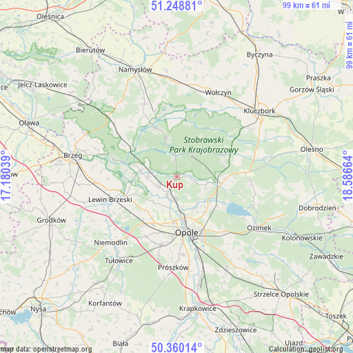
50° 48' 23.724" North, 17° 53' 0.636" East
| Map corner | latitude | longitude |
|---|---|---|
| Upper-left | 51.24881°, | 17.18039° |
| Center: | 50.80659°, | 17.88351° |
| Lower-right: | 50.36014°, | 18.58664° |
| Map W x H: | 98.8×98.8 km | = 61.4×61.4mi |
| max Lat: | 54.83135° ⇑60% North |
| Kup: | 50.80659° |
| min Lat: | ⇓40% South 49.21328° |
| min Long | Kup | max Long |
| 14.20249° | 17.88351° | 24.03723° |
| W 23.6%⇐ | ⇒76.4% E |
Elevation
Elevation of Kup is 158 m = 518 ft, and this is 33.4 m = 110 ft below average elevation for this country.
| Max E: |
974 m = 3196 ft | 55.3% |
| Avg. | 191.4 m = 628 ft | |
| Kup | 158 m = 518 ft | |
Min E: |
-3 m = -10 ft | 44.7% |
See also: Poland elevation on elevation.city.
Geographical zone
Kup is located in North temperate zone (between Tropic of Cancer and the Arctic Circle). Distance of this North polar circle is 1752 km =1088.6 mi to North.| Distance of | km | miles | from Kup |
|---|---|---|---|
| North Pole | 4357.9 | 2707.9 | to North |
| Arctic Circle | 1752 | 1088.6 | to North |
| Tropic Cancer | 3043.2 | 1891 | to South |
| Equator | 5649.2 | 3510.2 | to South |


Nearby cities:
15 places around Kup: (largest is in red/bold)
• Borkowice
13.9 km =8.6 mi,  238°
238°
• Chróścice
5.8 km =3.6 mi, 240°
• Czarnowąsy
8.7 km =5.4 mi,  173°
173°
• Dobrzeń Wielki
5 km =3.1 mi,  211°
211°
• Domaradz
15.8 km =9.8 mi,  355°
355°
• Karczów
13.4 km =8.3 mi, 211°
• Murów
7.6 km =4.7 mi,  34°
34°
• Opole
15.2 km =9.4 mi, 168°
• Pokój
11.2 km =7 mi,  343°
343°
• Popielów
10.1 km =6.3 mi,  282°
282°
• Skorogoszcz
15.1 km =9.4 mi,  249°
249°
• Swierkle
5.8 km =3.6 mi,  144°
144°
• Turawa
15.5 km =9.6 mi,  118°
118°
• Węgry
11.8 km =7.3 mi,  126°
126°
• Łubniany
8.6 km =5.3 mi,  105°
105°
Sources, notices
• [Note1] Compared only with cities in Poland existing in our database
• [Src1] Map data: © OpenStreetMap contributors (CC-BY-SA)
• [Src2] Other city data from geonames.org with taken over terms of usage.
• [Src3] Geographical zone / Annual Mean Temperature by Robert A. Rohde @ Wikipedia
