Zarzecze geodata
Zarzecze (Lesser Poland) is a populated place; located in Poland in Europe/Warsaw (GMT+2) time zone. With population of 1,200 people, there are 2164 cities with bigger population in this country. Compared to other cities in Poland, 70.4% of cities are located further ↑North; 52.7% of cities are located further ←West and 92.6% of cities have lower elevation than Zarzecze. Note1


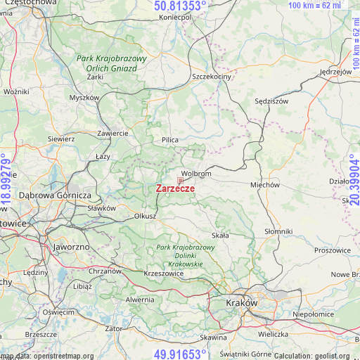
Zarzecze GPS coordinates[2]
50° 22' 1.74" North, 19° 41' 45.276" East
| Map corner | latitude | longitude |
|---|---|---|
| Upper-left | 50.81353°, | 18.99279° |
| Center: | 50.36715°, | 19.69591° |
| Lower-right: | 49.91653°, | 20.39904° |
| Map W x H: | 99.7×99.7 km | = 62×62mi |
| max Lat: | 54.83135° ⇑70.4% North |
| Zarzecze: | 50.36715° |
| min Lat: | ⇓29.6% South 49.21328° |
| min Long | Zarzecze | max Long |
| 14.20249° | 19.69591° | 24.03723° |
| W 52.7%⇐ | ⇒47.3% E |
Elevation
Elevation of Zarzecze is 364 m = 1194 ft, and this is 172.6 m = 566 ft above average elevation for this country.
| Max E: |
974 m = 3196 ft | 7.4% |
| Zarzecze | 364 m 1194 ft | |
| Avg. | 191.4 m = 628 ft | |
Min E: |
-3 m = -10 ft | 92.6% |
See also: Poland elevation on elevation.city.
Geographical zone
Zarzecze is located in North temperate zone (between Tropic of Cancer and the Arctic Circle). Distance of this North polar circle is 1800.9 km =1119 mi to North.| Distance of | km | miles | from Zarzecze |
|---|---|---|---|
| North Pole | 4406.8 | 2738.3 | to North |
| Arctic Circle | 1800.9 | 1119 | to North |
| Tropic Cancer | 2994.4 | 1860.6 | to South |
| Equator | 5600.3 | 3479.9 | to South |


Nearby cities:
15 places around Zarzecze: (largest is in red/bold)
• Bolesław
17.1 km =10.6 mi,  243°
243°
• Klucze
10.1 km =6.3 mi,  249°
249°
• Ogrodzieniec
15.6 km =9.7 mi,  307°
307°
• Olkusz
13.3 km =8.3 mi,  224°
224°
• Osiek
15.3 km =9.5 mi,  206°
206°
• Pilica
11.5 km =7.1 mi,  346°
346°
• Poręba Górna
6.9 km =4.3 mi,  102°
102°
• Przeginia
14.3 km =8.9 mi,  182°
182°
• Sieniczno
12.6 km =7.8 mi, 208°
• Sułoszowa
11.3 km =7 mi,  166°
166°
• Sąspów
16.3 km =10.1 mi,  161°
161°
• Trzyciąż
8.1 km =5 mi,  141°
141°
• Wierzchowisko
8.5 km =5.3 mi,  84°
84°
• Wolbrom
4.6 km =2.9 mi,  72°
72°
• Żarnowiec
17.1 km =10.6 mi,  43°
43°
Sources, notices
• [Note1] Compared only with cities in Poland existing in our database
• [Src1] Map data: © OpenStreetMap contributors (CC-BY-SA)
• [Src2] Other city data from geonames.org with taken over terms of usage.
• [Src3] Geographical zone / Annual Mean Temperature by Robert A. Rohde @ Wikipedia
