Poręba Górna geodata
Poręba Górna (Lesser Poland) is a populated place; located in Poland in Europe/Warsaw (GMT+2) time zone. With population of 540 people, there are 3429 cities with bigger population in this country. Compared to other cities in Poland, 70.7% of cities are located further ↑North; 54.6% of cities are located further ←West and 97.1% of cities have lower elevation than Poręba Górna. Note1


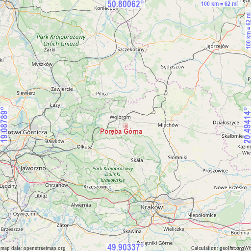
Poręba Górna GPS coordinates[2]
50° 21' 14.796" North, 19° 47' 27.636" East
| Map corner | latitude | longitude |
|---|---|---|
| Upper-left | 50.80062°, | 19.08789° |
| Center: | 50.35411°, | 19.79101° |
| Lower-right: | 49.90337°, | 20.49414° |
| Map W x H: | 99.8×99.8 km | = 62×62mi |
| max Lat: | 54.83135° ⇑70.7% North |
| Poręba Górna: | 50.35411° |
| min Lat: | ⇓29.3% South 49.21328° |
| min Long | Poręba Górna | max Long |
| 14.20249° | 19.79101° | 24.03723° |
| W 54.6%⇐ | ⇒45.4% E |
Elevation
Elevation of Poręba Górna is 477 m = 1565 ft, and this is 285.6 m = 937 ft above average elevation for this country.
| Max E: |
974 m = 3196 ft | 2.9% |
| Poręba Górna | 477 m 1565 ft | |
| Avg. | 191.4 m = 628 ft | |
Min E: |
-3 m = -10 ft | 97.1% |
See also: Poland elevation on elevation.city.
Geographical zone
Poręba Górna is located in North temperate zone (between Tropic of Cancer and the Arctic Circle). Distance of this North polar circle is 1802.3 km =1119.9 mi to North.| Distance of | km | miles | from Poręba Górna |
|---|---|---|---|
| North Pole | 4408.2 | 2739.1 | to North |
| Arctic Circle | 1802.3 | 1119.9 | to North |
| Tropic Cancer | 2992.9 | 1859.7 | to South |
| Equator | 5598.9 | 3479 | to South |


Nearby cities:
15 places around Poręba Górna: (largest is in red/bold)
• Jerzmanowice
16 km =9.9 mi,  191°
191°
• Klucze
16.4 km =10.2 mi,  262°
262°
• Kępie
15.6 km =9.7 mi,  41°
41°
• Miechów Charsznica
12.2 km =7.6 mi,  67°
67°
• Pilica
15.8 km =9.8 mi,  323°
323°
• Przeginia
14.8 km =9.2 mi,  209°
209°
• Sieniczno
15.9 km =9.9 mi,  232°
232°
• Skała
14.4 km =8.9 mi,  162°
162°
• Sułoszowa
10.4 km =6.5 mi,  203°
203°
• Sąspów
14 km =8.7 mi, 186°
• Trzyciąż
5.2 km =3.2 mi, 198°
• Wierzchowisko
2.9 km =1.8 mi, 36°
• Wolbrom
3.7 km =2.3 mi, 320°
• Zarzecze
6.9 km =4.3 mi,  282°
282°
• Żarnowiec
14.7 km =9.1 mi,  19°
19°
Sources, notices
• [Note1] Compared only with cities in Poland existing in our database
• [Src1] Map data: © OpenStreetMap contributors (CC-BY-SA)
• [Src2] Other city data from geonames.org with taken over terms of usage.
• [Src3] Geographical zone / Annual Mean Temperature by Robert A. Rohde @ Wikipedia
