Myślenice geodata
Myślenice (Lesser Poland) is a seat of a second-order administrative division; located in Poland in Europe/Warsaw (GMT+2) time zone. With population of 17,686 people, there are 280 cities with bigger population in this country. Compared to other cities in Poland, 90.4% of cities are located further ↑North; 57.4% of cities are located further ←West and 87.3% of cities have lower elevation than Myślenice. Note1


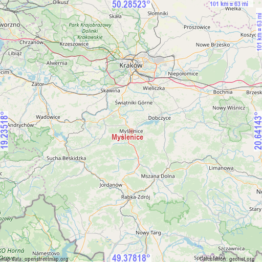
Myślenice GPS coordinates[2]
49° 50' 1.788" North, 19° 56' 17.88" East
| Map corner | latitude | longitude |
|---|---|---|
| Upper-left | 50.28523°, | 19.23518° |
| Center: | 49.83383°, | 19.9383° |
| Lower-right: | 49.37818°, | 20.64143° |
| Map W x H: | 100.9×100.9 km | = 62.7×62.7mi |
| max Lat: | 54.83135° ⇑90.4% North |
| Myślenice: | 49.83383° |
| min Lat: | ⇓9.6% South 49.21328° |
| min Long | Myślenice | max Long |
| 14.20249° | 19.9383° | 24.03723° |
| W 57.4%⇐ | ⇒42.6% E |
Elevation
Elevation of Myślenice is 304 m = 997 ft, and this is 112.6 m = 369 ft above average elevation for this country.
| Max E: |
974 m = 3196 ft | 12.7% |
| Myślenice | 304 m 997 ft | |
| Avg. | 191.4 m = 628 ft | |
Min E: |
-3 m = -10 ft | 87.3% |
See also: Poland elevation on elevation.city.
Geographical zone
Myślenice is located in North temperate zone (between Tropic of Cancer and the Arctic Circle). Distance of this North polar circle is 1860.2 km =1155.9 mi to North.| Distance of | km | miles | from Myślenice |
|---|---|---|---|
| North Pole | 4466.1 | 2775.1 | to North |
| Arctic Circle | 1860.2 | 1155.9 | to North |
| Tropic Cancer | 2935.1 | 1823.8 | to South |
| Equator | 5541 | 3443 | to South |


Nearby cities:
15 places around Myślenice: (largest is in red/bold)
• Borzęta
4.3 km =2.7 mi,  42°
42°
• Bęczarka
7.1 km =4.4 mi,  313°
313°
• Głogoczów
8.2 km =5.1 mi,  325°
325°
• Jasienica
7 km =4.3 mi,  259°
259°
• Jawornik
4.1 km =2.5 mi, 307°
• Krzyszkowice
5.6 km =3.5 mi,  348°
348°
• Osieczany
3.3 km =2.1 mi,  72°
72°
• Polanka
3.1 km =1.9 mi,  0°
0°
• Poręba
7 km =4.3 mi,  126°
126°
• Rudnik
6.8 km =4.2 mi,  287°
287°
• Stróża
4.3 km =2.7 mi,  194°
194°
• Trzebunia
8.1 km =5 mi,  234°
234°
• Trzemeśnia
6 km =3.7 mi,  96°
96°
• Zasań
8 km =5 mi, 100°
• Łęki
5.6 km =3.5 mi,  88°
88°
Sources, notices
• [Note1] Compared only with cities in Poland existing in our database
• [Src1] Map data: © OpenStreetMap contributors (CC-BY-SA)
• [Src2] Other city data from geonames.org with taken over terms of usage.
• [Src3] Geographical zone / Annual Mean Temperature by Robert A. Rohde @ Wikipedia
