Stróża geodata
Stróża (Lesser Poland) is a populated place; located in Poland in Europe/Warsaw (GMT+2) time zone. With population of 2,900 people, there are 1090 cities with bigger population in this country. Compared to other cities in Poland, 91.9% of cities are located further ↑North; 57.1% of cities are located further ←West and 87.2% of cities have lower elevation than Stróża. Note1


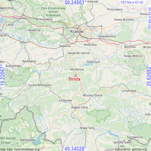
Stróża GPS coordinates[2]
49° 47' 46.608" North, 19° 55' 25.644" East
| Map corner | latitude | longitude |
|---|---|---|
| Upper-left | 50.24803°, | 19.22067° |
| Center: | 49.79628°, | 19.92379° |
| Lower-right: | 49.34028°, | 20.62692° |
| Map W x H: | 100.9×100.9 km | = 62.7×62.7mi |
| max Lat: | 54.83135° ⇑91.9% North |
| Stróża: | 49.79628° |
| min Lat: | ⇓8.1% South 49.21328° |
| min Long | Stróża | max Long |
| 14.20249° | 19.92379° | 24.03723° |
| W 57.1%⇐ | ⇒42.9% E |
Elevation
Elevation of Stróża is 302 m = 991 ft, and this is 110.6 m = 363 ft above average elevation for this country.
| Max E: |
974 m = 3196 ft | 12.8% |
| Stróża | 302 m 991 ft | |
| Avg. | 191.4 m = 628 ft | |
Min E: |
-3 m = -10 ft | 87.2% |
See also: Poland elevation on elevation.city.
Geographical zone
Stróża is located in North temperate zone (between Tropic of Cancer and the Arctic Circle). Distance of this North polar circle is 1864.3 km =1158.4 mi to North.| Distance of | km | miles | from Stróża |
|---|---|---|---|
| North Pole | 4470.2 | 2777.7 | to North |
| Arctic Circle | 1864.3 | 1158.4 | to North |
| Tropic Cancer | 2930.9 | 1821.2 | to South |
| Equator | 5536.8 | 3440.4 | to South |


Nearby cities:
15 places around Stróża: (largest is in red/bold)
• Borzęta
8.3 km =5.2 mi,  28°
28°
• Jasienica
6.6 km =4.1 mi,  296°
296°
• Jawornik
7 km =4.3 mi,  341°
341°
• Krzczonów
6.5 km =4 mi,  183°
183°
• Myślenice
4.3 km =2.7 mi,  14°
14°
• Osieczany
6.6 km =4.1 mi,  39°
39°
• Pcim
6 km =3.7 mi,  145°
145°
• Polanka
7.3 km =4.5 mi, 8°
• Poręba
6.7 km =4.2 mi,  89°
89°
• Rudnik
8.3 km =5.2 mi,  318°
318°
• Tokarnia
8.5 km =5.3 mi,  206°
206°
• Trzebunia
5.5 km =3.4 mi,  264°
264°
• Trzemeśnia
7.9 km =4.9 mi,  63°
63°
• Zasań
9.4 km =5.8 mi,  73°
73°
• Łęki
8 km =5 mi, 56°
Sources, notices
• [Note1] Compared only with cities in Poland existing in our database
• [Src1] Map data: © OpenStreetMap contributors (CC-BY-SA)
• [Src2] Other city data from geonames.org with taken over terms of usage.
• [Src3] Geographical zone / Annual Mean Temperature by Robert A. Rohde @ Wikipedia
